What to Expect at Queens Bus Network Redesign Final Plan Public Hearing

By Joseph Morales

Queens is New York City’s largest borough by land area and second largest by population. Like other parts of the city, many residents rely on public transportation to get around. According to data from the NYC Department of City Planning, 37% of Queens’ households do not have access to a vehicle. This does not reflect the thousands of teens who do not drive and also rely on mass transit to get to school and other activities. 

Read More »

Could There Be More Bronx Express Bus Changes?

By Joseph Morales

     Express buses are critical transportation assets for residents of the outer boroughs. In areas far from Manhattan, subway service, or both, express buses are often the only direct mass transit link between many communities and Manhattan. As congestion pricing nears, many may turn to express buses to avoid the even higher costs associated with driving in Manhattan. In February 2020, about 42,000 riders took express buses daily, according to the Gothamist.

                While express buses are important citywide, they are especially critical in The Bronx. Here, express buses serve many riders across the borough who live far from the subway, particularly in the East Bronx. Even in places with nearby subway service, many use express buses to get where their subway route may not take them. For example, a Parkchester resident commuting to work on the West Side of Manhattan may ride the BxM6 instead of the 6 train as the 6 train only serves Lexington Av while the bus serves 5th Avenue. In addition, only 45-66% of households in Bronx Community Districts with express bus routes have a car. Hence, express buses serve as one of the few transportation options for many residents, particularly those without access to subway service.

                Outside of commuting into Manhattan, many people in Manhattan use express buses to reverse commute to destinations in The Bronx. For instance, the BxM10 stop adjacent to the Albert Einstein College of Medicine in the Morris Park neighborhood is always bustling with commuters every morning. In 2019, according to the site Pedestrian Observations, almost 32,000 people commuted from Manhattan to The Bronx for work. Additionally, many tourists likely ride the BxM11 to visit the iconic Bronx Zoo and New York Botanical Gardens. 

                 Given the systems’ use and growth over the years, one would have expected substantial improvements to the express bus network as part of the recent Bronx Bus Network Redesign. The MTA did propose a plethora of changes to express bus routes. The most notable included a new route between Co-Op City and Lower Manhattan and more direct service on many routes. However, many Bronxites were furious at some proposed changes, which reduced operating hours and service frequency on almost all express bus routes. This led to all proposed express bus changes being revoked before the implementation of the bus network redesign.

                   Despite this, the MTA has made some small but considerable express bus improvements for Bronx Express Buses within the last few months. On several routes, the MTA has added a new stop at 96th St in both directions for riders on the BxM10. This provides riders with new connections to parts of the Upper East Side as the next closest stop was at 5 Av/E 85th St. Additionally, the MTA added a new stop at 125th St on the BxM2, which did not have a stop in Harlem, providing new connections there as well. For reverse commuters, the MTA added a stop at Morris Park Ave/1300 Morris Park Ave on the BxM10 to better serve commuters headed to the Albert Einstein College of Medicine.

Signage indicating bus stop changes on BxM2 at the intersection of W 230th St/Tibbett Av.

                     With these small improvements, should we see more significant changes to the express bus system? If so, what changes should those be? To answer these questions, we have to look at the things express bus riders want from the system. There have been few major calls for specific express bus improvements during the bus network redesign process beyond what already exists. However, one can think about what the subway system provides(connections to different places, frequent service) and infer that express bus riders would the same.

                       Hence, express bus service improvements could include more service to Lower Manhattan, which only one peak-hours-only route provides. Also, since many are concerned about crime in the subways and the subway is the primary way to get to Lower Manhattan via a transfer, this may encourage more Lower Manhattan trips. Additionally, more bus routes could have stops on 96th St on the Upper East Side(UES) due to the noticeable service gap on the UES and in East Harlem. On most express bus routes, the only stops on the UES are at 5th Ave/85th St and below, making trips between 90th and 116th Sts more difficult. Both of these proposals were pursued to an extent in the Bronx Bus Network Redesign Draft Plan. There, the MTA proposed that almost all routes have a stop at E 96th St in both directions. The MTA also proposed a new route, the BxM17, to connect one of the most densely populated sections of the East Bronx, Co-Op City, with Lower Manhattan.

                           Another significant addition Bronx Express bus riders would love to see is more frequent service. Currently, most express bus routes only run every 30-60 min, leaving riders little flexibility when it comes to travel times. Between this and how often buses get stuck in Manhattan/Bruckner Expwy traffic, this leads to express bus riders having some of the longest and most stressful commutes out of all transit riders. In addition, many express bus riders are deterred from taking the subway due to fears of subway crime and still want to take the subway into Manhattan. At the final hearing for the Bronx Bus Network Redesign in November 2021, several Bronxites expressed this concern despite it already being announced that express bus changes were canceled. Karina Hammer of University Heights told MTA officials, “I refuse to take the subways due to the high crime we are facing with people getting attacked and mugged. I feel so much safer when I use the express bus.” Another bus rider, Patricia Nunez from Riverdale, also shared concerns, saying, “It’s been a horrible year on the subway with violent crime increases, mentally ill people pushing people onto the subway tracks, we cannot take the subway, we really need the BxM1 and the BxM2.

                    Outside of more frequent service, the MTA can also tweak routes to avoid highly trafficked areas in its nonstop segments. As many still work from home, Manhattan car traffic is less than it was prepandemic. Now, the primary source of express bus trip delays comes from nonstop segments on highways. The most substantial of such is on the BxM6, 7, 8,9, and 10 during the PM peak on the eastbound Bruckner Expwy. Here, buses have been dealing with congestion due to the recent construction projects on the highway. In this case, the MTA can consider rerouting express buses to run on Bruckner Blvd underneath the expressway instead during certain times. This will lead to faster and more reliable service for a substantial number of riders. 

                   In addition, routes could also be adjusted to provide more reliable service and service to areas that do not currently have it. Before express bus service changes were paused, the MTA proposed to shorten the BxM4 only to serve the Grand Concourse and Bedford Park and create a new BxM5 to directly serve Woodlawn, Wakefield, and the city of Mt Vernon. This proposal would have substantially reduced travel time for Woodlawn riders as their routes would not have to spend 5 miles on the oft-congested Grand Concourse. The new routing alignment will also provide a more direct bus option for Wakefield riders and provide service for Mt Vernon riders who do not have express bus service. However, in addition to the alignment the MTA initially proposed, the MTA can also consider extending the proposed BxM5 further down 3rd St and to the Mt.Vernon East MNR station. The MTA could also provide weekend service at a reasonable frequency for both routes, which was not proposed in the redesign plan.

                 The extension of the BxM5 would provide direct transit service to Manhattan for a densely populated community that lacks quality transit options. Despite being denser than many Bronx neighborhoods, routes run only a few times a day during rush hours to Bronx subway stations. This is despite Mt Vernon being directly adjacent to The Bronx and not far from subway stations in comparison to other Bronx neighborhoods that are well served by subway-connecting bus routes. The only other transit service to Manhattan is the Metro-North at Mt Vernon East, which is infrequent and expensive. According to a city document, the Southern side of Mt Vernon, where the rail station is located, has many census tracts with a median income of $39,999 or less and a poverty rate above 25%. Hence, a lower-cost express bus route can be a significant mobility improvement for Mt Vernon residents.

                  While these improvements could be huge for riders, there are significant barriers to implementing any of them. The most considerable constraint is undoubtedly cost. According to data from the Gothamist, express buses receive a public subsidy of $11.79 per person, higher than the next highest subsidy of $6.07 per person for the LIRR. Given how these buses get fewer riders than other modes, it may be hard for the MTA to justify increasing service. This is likely a large part of why they initially planned to cut service on express bus routes during the Bronx Bus Network Redesign. 

                       Nonetheless, increasing service and making routing adjustments could benefit MTA finances in the long run if it encourages more ridership. In much of the U.S., a significant issue with public transit is when there is less ridership due to infrequent service, leading to even more reduced service. This is often known as the transit “death spiral.” It is unknown whether this is precisely what’s happening to Bronx express buses as most commuters going into Manhattan go via mass transit regardless of whether or not they own a car. However, it is also worth noting that many are avoiding the subway and even working in person due to crime concerns. Additionally, $15 congestion pricing tolls for Manhattan drivers below 60th St is on the horizon. Hence, better express bus service may generate more trips into Manhattan, making the costs of operating buses more practical while improving the transit experience for many riders. 

                         As the redesign of Bronx Express bus routes was stopped suddenly, people may wonder when and if any changes will come to the network. The MTA has not said much about express bus redesign except that “There are currently no changes to express routes at this time.” in the Bronx Bus Network Redesign Final Plan Addendum. Hopefully, any changes made to the express bus network can improve connections to Manhattan for Bronx commuters for years to come.

Works Cited

Howard, Shawyn Patterson, and Dr. Darren Morton. “Draft 2020-24-Analysis of Impediments To Fair Housing Choice Plan.” City of Mount Vernon, 10 February 2020, https://cmvny.com/ArchiveCenter/ViewFile/Item/114. Accessed 7 April 2024.

Metropolitan Transportation Authority. “The Bronx Bus Network Redesign Final Plan Addendum.” MTA, November 2021, https://new.mta.info/document/63526. Accessed 7 April 2024.

Metropolitan Transportation Authority. “Draft Plan-Bronx Bus Network Redesign.” MTA, May 2019, https://new.mta.info/sites/default/files/2019-06/410_19_BBNR%20Existing%20Report_Final_2019_v2.pdf. Accessed 7 April 2024.

mtainfo. “Bronx Bus Network Redesign Restart – 11/09/2021.” YouTube, 9 November 2021, https://www.youtube.com/watch?v=7U_Lt-uof9U. Accessed 7 April 2024.

Nessen, Stephen, et al. “MTA Still Running Heavily-Subsidized Express Bus Service Despite Few Riders.” Gothamist, 24 March 2021, https://gothamist.com/news/mta-still-running-heavily-subsidized-express-bus-service-despite-few-riders. Accessed 7 April 2024.

New York City Department of City Planning-Transportation. “Car Ownership in NYC.” Tableau, 24 November 2022, https://public.tableau.com/app/profile/dcptransportation/viz/ACSProfiles/Dashboard1. Accessed 7 April 2024.

O’Toole, Randal. “Transit Death Spiral.” Downsizing the Federal Government, 14 May 2019, https://www.downsizinggovernment.org/transit-death-spiral. Accessed 7 April 2024.

“Reverse- and Through-Commute Trends.” Pedestrian Observations, 14 November 2023, https://pedestrianobservations.com/2023/11/14/reverse-and-through-commute-trends/. Accessed 7 April 2024.

Siff, Andrew, and Jennifer Millman. “NYC congestion pricing plan approved by MTA board – NBC New York.” NBC New York, 27 March 2024, https://www.nbcnewyork.com/traffic/transit-traffic/congestion-pricing-nyc-mta-vote/5264500/. Accessed 7 April 2024.

How Can New State Legislation Impact New York City Transit?

By Joseph Morales

Public transportation is the backbone of New York City. Due to the city’s congestion and limited parking space, many take public transportation to avoid the hassles associated with driving. Given the city’s high cost of living, many find driving to be prohibitively expensive and hence also decide to opt for transit. As a result of these factors and others, 46% of New Yorkers do not own a car and hence rely on public transit to get wherever they need to go. This tally does not include suburbanites who take mass transit in New York City in lieu of driving for the same reasons as residents. 

Read More »

Why The Upcoming MTA Capital Projects Hearing Is Important

By Joseph Morales

For more information or to sign up to speak the MTA’s hybrid Capital Projects Hearing on February 6th, click here: https://new.mta.info/transparency/public-hearings/2024-capital-projects-hearing

     In New York City, much of the population relies on mass transit run by the MTA(Metropolitan Transportation Authority)to get around. According to data from the NYC Department of City Planning, only 46% of city households own a car. Even vehicle owners often use mass transit to get to Manhattan due to traffic congestion and high parking costs. Additionally, hundreds of thousands of riders from outside of the city ride the Metro-North and LIRR commuter rails to get around the suburbs as well as into the city daily. Given how many people it moves, the MTA also plays a major part in New York’s economy. An NYU study from October 2020 found that a 40% reduction in bus/subway service and a 50% reduction in commuter rail service would cost riders more than $1.7 billion in lost time each year. This is only reflective of the impact of transit service reduction and does not reflect the impact of if mass transit were to not exist at all.

Read More »

How Can Bus/Pedestrian Conditions Be Improved on Tremont Avenue?

By Joseph Morales

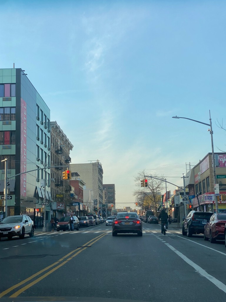
   Tremont Avenue in The Bronx is one of the busiest east-west streets in the borough. In addition, it is one of The Bronx’s longest streets at about 7 miles between the Throggs Neck and Morris Heights neighborhoods. The street crosses the entire borough and connects to several other major corridors such as White Plains Rd, Third Ave, and University Ave. Tremont Ave also runs parallel, to the Cross Bronx Expwy, which provides drivers an alternative to one of the most congested highways in the Northeast. In addition, Tremont Avenue provides access to several major destinations such as the River Park Towers and Crotona Park. Every subway route in The Bronx has a stop on or within a 3 minute walk of Tremont Ave. Additionally, Tremont Ave is served by the Metro-North’s Harlem and New Haven Lines at the Tremont Station. As for buses, Tremont Ave is served by the Bx40, Bx42 and Bx36 routes, that provide connections to various communities across the Bronx with the Bx36 going to Washington Heights, Manhattan. 

         As you can imagine, Tremont Avenue is known for its congestion that leads to slow travel speeds especially for bus riders. Tremont Avenue is especially known for slow bus speeds between University Avenue and Boston Rd. During rush hours, buses average speeds of less than 5 to 8 mph in most sections in both directions. As 29,000 ride the bus through here daily and 72% of nearby residents do not own a car according to the NYCDOT, bus service here is critical to people getting around. Unfortunately, Tremont Avenue’s high volume also in part contributes to safety risks. Between 2016-2020, 1,100 were injured in crashes on Tremont with 215 of them being pedestrians. The intersections of Tremont Ave and the Grand Concourse, Anthony Ave and Boston Rd are considered Vision Zero Priority Intersections respectively. 

            Due to the slow bus speeds and safety conditions, the New York City Department of Transportation(NYCDOT), is developing a plan to improve Tremont Ave between Boston Rd and University Ave for all road users. The agency has already taken several steps in order to so. In 2016, the agency added a combination of traditional and shared bike lanes, curb extensions and better lane markings for the purpose of improving safety for cyclists between Boston Rd and Tremont’s western terminus at Sedgwick Ave. As for bus speeds, the MTA and NYCDOT proposed adding Select Bus Service to Tremont as part of the 2017 Bus Forward Plan. This would have included the addition of off-board fare collection and likely bus lanes. There has been no discussion of SBS implementation during the recent Bronx Bus Network Redesign or the NYCDOT’s current project.

               As for what the NYCDOT’s current plans are, it seems like anything is on the table. In their recent presentation to Bronx Community Advisory Board 1, they showed their transit toolkit which included everything from curbside bus lanes to transit-exclusive busways. In addition, they demonstrated bus boarding islands and pedestrian islands that could help shorten crossing distances for pedestrians and have them wait for the bus in safer places. They also presented ways to make the bus stop more comfortable for riders, through means like benches and leaning bars. 

              Given how slow buses on Tremont, it would not be surprising to see the NYCDOT propose almost any of the street additions they presented to the Community Advisory Board. The most significant change, a busway, is already in place on the nearby 181st St in Washington Heights. The nearby Fordham Rd in The Bronx , was also slated to get a busway, but it was nixed due to opposition from local businesses and the lack of alternatives for drivers could have resulted in gridlock conditions of nearby side streets. As busways have usually only been on the absolute slowest corridors, a busway on Tremont Ave does seem to be unlikely. While Tremont’s speeds are as slow as some busway corridors have been in some spots, it is just not as consistently slow as corridors like 181st St have been. Busways are likely saved for the slowest corridors due to opposition they have received in nearly each instance from drivers and businesses due to the inability to drive and park on the corridor. As cars often double park to access the various retail stores on Tremont, a busway will likely not sit well with many road users. 

Several cars double parked on a Sunday Afternoon at E Tremont Av/Mapes Av
Multiple cars parked in bike lane on E Tremont Av/Crotona Av

               While a busway may not work, the NYCDOT will almost certainly propose some sort of bus lane for the corridor. A center running bus lane is likely unfeasible as the corridor is not as wide as those such as E 161st St where center running lanes have been implemented. However, an offset or curbside bus lane definitely has a significant chance of being proposed. A curbside lane is exactly what it sounds like while an offset lane, is the use of the rightmost travel lane as a bus lane. Both may generate opposition from drivers due to either the loss of road space or parking space depending on which setup the NYCDOT wants to go with. Regardless, the NYCDOT will likely go with the curbside lane due to the street having only one travel, parking and in some parts a bike lane in each direction. In a presentation to Manhattan Community Board 3 regarding another bus improvement project, the agency said that curbside bus lanes were reserved for narrower corridors while offset bus lanes are set for corridors with more space. Therefore, this is likely the NYCDOT’s best chance at striking a balance between the needs of motorists and bus riders. 

Tremont Avenue at Prospect Ave with one travel lane and one bike lane in each direction.

                Outside of bus lanes, the NYCDOT is considering adding Transit Signal Priority(TSP) to Tremont so that buses either have extended or early green lights so that buses could proceed faster through intersections. This could definitely be helpful as TSP on five busy routes citywide sped up buses by an average of 18% according to NYCDOT data. Additionally, the NYCDOT and the MTA have already worked to install ABLE cameras on the Bx36 route that runs along the corridor due to enforce the bus lanes and busways respectively on University Ave in The Bronx and 181st St in Manhattan. Even without Tremont Ave bus lanes, the cameras already help improve reliability on Tremont Ave by but it already helps improve overall reliability on Tremont Ave by preventing the bus from being late to Tremont Ave riders due to congestion in other areas.

             In regards to bus stops, any of the items in the NYCDOT’s toolkit are likely feasible at most stops along the corridor. In some cases, benches and leaning bars may be subject to spatial constraints, but they nonetheless could become a common sight. The most significant obstacle to getting bus stop upgrades will almost certainly be the city’s budget cuts, initiated by Mayor Eric Adams due to the migrant crisis among other issues. The cuts have even gotten to the point where the New York City Department of Parks and Recreation is maintaining less trash bins and cutting back substantially on park cleaning and maintenance. Given the NYCDOT’s commitment to street improvement projects across the city despite the cuts, small bus stop upgrades will likely not be the agency’s priority.

               In addition, most of the NYCDOT’s pedestrian toolkit should be able to come in handy. While bus boarding islands may be difficult due to spatial constraints, smaller pedestrian islands could help to reduce crossing distances and improve safety. Data from the Federal Highway Administration shows that these islands can help to reduce pedestrian crashes by 32%, indicating their effectiveness. The NYCDOT is also considering left and right turn bays at select intersections for drivers to make their turns. Left turns are notoriously dangerous as they involve drivers turning at a higher radius and speed coupled with crossing oncoming traffic. A 2016 study from the NYCDOT shows that left turn bays reduced pedestrian and cyclist injuries by 15%, meaning these bays could help to save lives on the road.

              All in all, the NYCDOT’s decision on what to implement on Tremont Ave will likely depend on the needs of the community as well as the risks and benefits of each decision. As the corridor varies in population and commerical density, the NYCDOT broke it into five sections to determine which solutions fit best in each area. This may mean bus lanes or certain types of bus lanes in some spots or not others. This could also determine which pedestrian safety additions are pertinent to which intersections. Since most major decisions will include maintaining space for motorists or adding space for buses and pedestrians, any choices will likely not make everyone happy. The fact that people frequently access Tremont Ave by all modes will make these decisions even more difficult. As the NYCDOT is looking to make large scale improvements, hopefully they come to a solution that benefits all road users for years to come.

Works Cited

Barone, Vincent. “14th Street busway supporters slam block associations’ lawsuit as classist.” amNewYork, 1 July 2019, https://www.amny.com/transit/14th-street-busway-lawsuit-1-33243425/. Accessed 30 December 2023.

Duggan, Kevin. “‘We heard them’: Mayor Adams says ‘community leaders’ wanted 181st Street busway hours cut.” amNewYork, 1 August 2022, https://www.amny.com/transit/mayor-adams-defends-181-busway-community/. Accessed 30 December 2023.

Duggan, Kevin, and Dave Colon. “City Makes Jamaica Busways Permanent But With Shorter Hours; Begins Northern Blvd. Bus Lanes – Streetsblog New York City.” Streetsblog NYC, 15 November 2022, https://nyc.streetsblog.org/2022/11/15/city-makes-jamaica-busways-permanent-but-with-shorter-hours-begins-northern-blvd-bus-lanes. Accessed 30 December 2023.

Federal Highway Administration. “Pedestrian Refuge Island Safe Transportation for Every Pedestrian Countermeasure Tech Sheet.” FHWA Highway Safety Programs, June 2018, https://safety.fhwa.dot.gov/ped_bike/step/docs/techSheet_PedRefugeIsland2018.pdf. Accessed 30 December 2023.

Federal Highway Administration. “Pedestrian Refuge Island Safe Transportation for Every Pedestrian Countermeasure Tech Sheet.” FHWA Highway Safety Programs, June 2018, https://safety.fhwa.dot.gov/ped_bike/step/docs/techSheet_PedRefugeIsland2018.pdf. Accessed 30 December 2023.

Metropolitan Transportation Authority. “MTA Activates Bus Lane Enforcement Cameras Along Bx36 Route in the Bronx and Manhattan.” MTA, 16 June 2023, https://new.mta.info/press-release/mta-activates-bus-lane-enforcement-cameras-along-bx36-route-bronx-and-manhattan. Accessed 30 December 2023.

Nessen, Stephen, and Jessy Edwards. “Judge Clears Way For Flushing Bus Lane Opposed By Local Businesses.” Gothamist, 5 January 2021, https://gothamist.com/news/judge-clears-way-flushing-bus-lane-opposed-local-businesses. Accessed 30 December 2023.

New York City Department of Transportation. “Better Buses for Restart.” NYC.gov, July 2021, https://www.nyc.gov/html/dot/downloads/pdf/m14ad-bus-priority-cb3-jul2021.pdf. Accessed 30 December 2023.

New York City Department of Transportation. “Bus Forward.” NYC.gov, 20 October 2017, https://www.nyc.gov/html/brt/downloads/pdf/bus-forward.pdf. Accessed 30 December 2023.

New York City Department Of Transportation. “DON’T CUT CORNERS-LEFT TURN Pedestrian & Bicyclist Crash Study.” NACTO.org, August 2016, https://nacto.org/wp-content/uploads/2017/11/left-turn-pedestrian-and-bicycle-crash-study-1.pdf. Accessed 30 December 2023.

New York City Department of transportation. “DOT Press Releases – DOT Releases Status Report on “Transit Signal Priority” Technology Used To Speed MTA Buses.” NYC.gov, 24 July 2017, https://www.nyc.gov/html/dot/html/pr2017/pr17-055.shtml. Accessed 30 December 2023.

New York City Department of Transportation. “181st Street Busway – Community Board Advisory Board Meeting – June 23, 2022.” NYC.gov, 23 June 2022, https://www.nyc.gov/html/dot/downloads/pdf/181-st-broadway-ave-amsterdam-ave-jun2022.pdf. Accessed 30 December 2023.

New York City Department of Transportation. “Tremont Ave.” NYC.gov, 21 January 2016, https://www.nyc.gov/html/dot/downloads/pdf/tremont-ave-cb6-jan2016.pdf. Accessed 30 December 2023.

New York City Department of Transportation. “Tremont Avenue Bus Priority Improvements – Community Advisory Board Meeting #1.” NYC.gov, 12 December 2022, https://www.nyc.gov/html/dot/downloads/pdf/tremont-ave-bus-priority-cab1-dec2022.pdf. Accessed 30 December 2023.

New York City Department of Transportation, and Metropolitan Transportation Authority. “Better Buses Restart: Downtown Flushing Main St. Busway – Community Advisory Board.” NYC.gov, 13 April 2021, https://www.nyc.gov/html/dot/downloads/pdf/main-st-flushing-busway-cab4-apr2021.pdf. Accessed 30 December 2023.

Rivoli, Dan. “Transit advocates rally for Fordham Road ‘busway.’” NY1, 11 July 2023, https://ny1.com/nyc/bronx/transit/2023/07/11/transit-advocates-rally-for-fordham-road–busway-. Accessed 30 December 2023.

Weaver, Shaye. “Here’s how the mayor’s budget cuts could affect your local park.” TimeOut, 15 December 2023, https://www.timeout.com/newyork/news/heres-how-the-mayors-budget-cuts-could-affect-your-local-park-121523. Accessed 30 December 2023.

MTA Debuts New Type of Bus Route in Queens Bus Network Redesign

By Joseph Morales

    Queens is New York City’s largest borough by land area and second in population, far surpassing that of Manhattan, The Bronx and Staten Island. Given its size and proximity to both Long Island and Manhattan, neighborhoods in Queens can range from suburban-like in Little Neck to Manhattan-like in Long Island City. Therefore, getting around Queens by public transit can mean traveling by various modes. In some parts of Central and Western Queens, the subway can easily be used in order to get from point A-point B east to west, while other trips require slower bus rides. In Eastern Queens, residents almost always have to rely on buses to get anywhere including to the subway. Many residents who can afford it can take the faster LIRR, however this may be prohibitively expensive for some even with the CityTicket. While buses in Eastern Queens do tend to be faster than other places, the length riders have to travel from here to subway stations still contributes to neighborhoods here having some of the longest commutes in the city.

Read More »

Could Recent Initiatives Encourage Transit Use in Connecticut?

By Joseph Morales

The State of Connecticut is a small state with a very diverse set of landscapes. Much of the state composes of small, but densely populated urban areas such as Hartford, New Haven, Bridgeport and Stamford. The state also has a plethora of smaller suburban cities and towns along with some rural areas. Many parts of the state are within commuting distance of New York City and 43,000 people commute from Connecticut into the city daily according to NYC Department of City Planning numbers. While the reverse commuting numbers are lower, 9,000 people also commute from NYC to Connecticut on a daily basis.

Read More »

Everyone Has Heard About Subway Deserts Before. What About Crosstown Bus Deserts?

By Joseph Morales

*Though some corridors that lack regularly scheduled frequent and reliable bus service are discussed, there may be some that I might have missed. If you think I missed a particularly slow and infrequent bus route, let me know in the comments!

New York City is undoubtedly the most transit dependent city in the United States, as only 46% of residents own a car according to data from the NYC Department of City Planning. New Yorkers opt to ride public transit for various reasons, from the parking and traffic challenges of driving to the sheer cost of more reliable modes. Unfortunately, most New Yorkers know that mass transit is not the same for everyone, as two million New Yorkers live in so called “transit deserts” with little to no access to subway service. These New Yorkers often face long bus rides to get to subway service and have commutes that are substantially longer than those who live in more subway-rich neighborhoods. 

Read More »

The OMNY Card Is Finally Available At Select Subway Stations, A Major Step In The OMNY Rollout

By Joseph Morales

 The One Metro New York(OMNY) system is slowly but surely becoming the dominant way New Yorkers pay to ride buses and subways throughout the city. With the rollout of OMNY beginning on select bus routes and at certain subway stations in 2019, riders have been able to tap their smart device or card on an OMNY reader to board the bus or subway, rather than use a prepaid MetroCard. The goal for the MTA has been to develop a contactless fare option that is more flexible and convenient for its riders. In addition to the added convenience for riders, OMNY has provided the MTA with the ability to implement fare policies they were not previously able to such as fare capping. With fare capping, riders who spend $34 or take 12 rides in a single week can ride free for the remainder of that week. Before fare capping, the same riders either had to pay for an Unlimited or Pay-Per-Ride MetroCard which often would have left them in situations where they paid for rides they did not take or wound up paying more for their rides because they did not purchase the Unlimited MetroCard. The MTA had planned to retire the MetroCard in favor of OMNY by the end of this year, however that has been delayed to 2024 due to software issues.

Read More »

Could We See More Bus-Only Traffic Signals in NYC?

By Joseph Morales

New York City’s public buses are a core part of its public transportation network. While the city is known for its subways, its bus network still serves over a million riders daily among its 327 bus routes. The city’s buses are also particularly helpful in helping people get to areas where the subway just does not go.

                       Whether people are riding the bus to the subway, to work or school, or traveling a long distance across their borough, everyone undoubtedly wants a fast and reliable trip to their destination. In many instances, however, it is hard for the MTA to provide for the simple fact that buses have to share road space with vehicles and, thus, they routinely run in congested traffic. A report from the state comptroller’s office in March 2023 showed that MTA buses in the five boroughs rarely averaged speeds above 9 mph. In comparison, an average man runs 8 mph. On many of the MTA’s slowest routes, speeds do not average much more than 3 mph, which is the average speed of a human walk. This issue is made worse by the fact that buses tend to make a good number of stops, and thus, they must merge back into traffic every time they do, slowing travel times.

Read More »