New Select Bus Service Could Form New Connection Between Southern Queens and Brooklyn

By Joseph Morales

Linden Boulevard is an interborough street that travels from the Cambria Heights section of Queens through the neighborhoods of St.Albans, South Jamaica and South Ozone Park. It is like many other stretches in the outer boroughs with a combination of businesses and single-family residences. In Queens Community Districts 10 and 12, which comprise much of the corridor, average commute times are 46.9  and 48.4 minutes respectively, which are among the longest commutes in the city. In both districts , about half of the residents have car-free commutes meaning mass transit is a major part of how people get around. Unfortunately for communities that rely on mass transit as much as these Southern Queens neighborhoods, there is no bus or subway route that travels straight along the Linden Blvd corridor. Currently, a trip across the corridor would require a diversion from Linden Blvd onto Merrick Blvd and into Downtown Jamaica, which is one of the busiest transit hubs in the entire city. Afterwards, a rider must transfer to another bus for a trip that can easily take over 2 hours during rush hour. 

Read More »

Underserved Transit Deserts in Westchester County May Soon Be Served By Microtransit

By Joseph Morales

          Westchester County arguably has more diverse travel markets than anywhere in New York State. The majority of Westchester County is full of suburban communities similar to those you’d see throughout America, where most residents own cars. However, Westchester County is also home to a few mid-sized cities and even slightly larger urban areas, particularly in the southern portion of the county. The cities of Yonkers, Mount Vernon, New Rochelle and White Plains contain 40% of the county’s population. Many, though not the majority of residents in these cities and in other areas are low-income and rely on public buses to get around the county as well as to get into The Bronx. Other residents of both the cities and the rest of the county may use public transit solely for connecting to Metro-North trains to get to Manhattan. Overall according to video by the Westchester County Government, 85% of Westchester County residents own cars. While this rate may seem high to city-dwellers, this is still less than the U.S rate of 91.5% of Americans owning cars according to the U.S Census. 

              Unfortunately, due to this level of diversity when it comes to travel demand, Westchester County has struggled to find ways to serve those who use mass transit, particularly in mid-sized areas. This is in part because mass transit is very expensive to operate and rarely turns a profit. Thus, the Bee-Line system needs a certain number of riders on its buses to justify running frequent service. This puts mid-sized cities such as Port Chester in a difficult position. According to the Urban Action Agenda’s Port Chester Community Profile in 2018, 14% of the population of about 29,000 took public transit to work. While this is a significant portion of the city’s population, this only equates to about 4,060 transit riders not including those who primarily use Metro-North rather than Bee-Line buses, making it hard to justify frequent transit service here.

Read More »

University Ave In The Bronx Is Receiving Major Upgrades To Bus and Bicycle Travel

By Joseph Morales

                  University Avenue in the Bronx, is a major street with many connections. The current amount of high traffic makes it difficult for buses to efficiently complete their runs and also causes dangerous conditions for cyclists. Currently, there are bus and bike improvements being made that will improve riding University Avenue and create a safe, smooth and reliable trip for everyone.

                 University Avenue is a high density residential and commercial corridor in The Bronx. In addition to its connections to major Bronx streets as well as Manhattan, the roadway can also be used to access the Cross Bronx Expressway and George Washington Bridge to New Jersey. The two main buses on University Ave(Bx3 and Bx36) cross the Washington Bridge to connect riders to Washington Heights, Manhattan, which is one of the most popular transit links in the Bronx. According to The Bronx Bus Redesign Existing Conditions Report, the travel pattern Burnside to Washington Heights had the 6th most trips between two TAZ’s (Transit Analysis Zones), and the travel pattern Morris Heights to Washington Heights ranked 20th which are both trips that are made via the Bx3 and Bx36 buses.

                Unfortunately for bus riders as per a presentation from the NYCDOT in October 2021, bus speeds along University Avenue during peak hours average 4 to 8 mph. These slow speeds result in a slow and unreliable commute for many, as the Bx3 that runs primarily on University Avenue received TransitCenter’s Schleppie award for being the Bronx’s most unreliable bus route in 2019, as 19.2% of buses arrived simultaneously due to delays on one of the buses. This makes it extremely difficult to get around the avenue and forces many residents to be late for work, school and other commitments.

                       This is set to change as a result of a bus priority project by the NYCDOT as part of former NYC Mayor Bill De Blasio’s Better Buses initiative. The plan includes offset bus lanes between the Washington Bridge and W Kingsbridge Road, bus lanes with protected bike lanes between West Tremont Avenue and West Burnside Avenue and bus lanes between West Burnside Avenue and The Washington Bridge. These bus lanes might help speed up buses and make commutes more convenient for everyone.                           

Read More »

How Might Free-Bee-Line Buses Impact A Socioeconomically Diverse Westchester County?

By Joseph Morales

               The Bee-Line Bus System in Westchester County has been free to ride since June 1st. The Bee-Line System is the main public bus system in Westchester County just outside of New York City. Typically, bus systems in suburbs throughout America sometimes implement free fares for a period of time to make an attempt at making public bus service an appealing alternative in relatively car-dependent areas such as when the MTA(Macon Transit Authority) ran a similar program on its buses serving Bibb County, GA last spring. While this may have been true in Westchester County as well, this summer long policy may have a much bigger impact on many Westchester County riders given the diverse range of population densities and transit propensity of people in Westchester County cities.


Read More »

The Bronx Bus Network Redesign is Finally In Effect!

By Joseph Morales


               After an almost two year delay caused by the COVID-19 pandemic and the budget woes that came along with it, the MTA has finally implemented the final plan for the Bronx Bus Network Redesign. Bronxites have waited patiently for this day in order to have a faster and more reliable system for many years. Many Bronxites who rely on buses live in areas that lack subway service or make crosstown trips for which there is no subway service except for at almost the very southernmost point of the borough.  Since about 60% of Bronxites do not own cars,(not including middle/high school students between the ages 12-18), buses are a critical part of mobility in the borough. Bronx Borough President Vanessa Gibson said this in a recent video on the redesign published on the mtainfo youtube channel, “People want to get to their destination safely, they want it to be efficient services, reliable and affordable. If you check all of those boxes, you will have happy commuters in our borough.”


Read More »

New Crosstown Bus Route Alignments Will Speed Up Crosstown Buses In The Bronx

By Joseph Morales

(Link to information on bus routes discussed in article located at the bottom after Works Cited section)

The MTA’s Bronx Bus Network Redesign is a plan to redesign the Bronx’s bus system to meet the needs of its riders and become a faster and more reliable system. Even though The Bronx has developed and evolved in many ways, the bus network has not been reevaluated in many years. With many bus routes still running the routes of old trolley lines, a redesign of the bus system is crucial to push bus operations in The Bronx into the 21st century. One of the biggest changes to the system in the redesign, are the restructuring of the Bx11, Bx35 and Bx36, routes which travel east-west across The Bronx from points in West Farms and Soundview across different corridors to W 181st St in the Washington Heights section of Manhattan. In addition, the Bx40 and Bx42 routes that run between the Throggs Neck section of the Bronx and the Highbridge area of the borough are also being restructured. The purpose of this route restructuring is to reduce the number of turns and avoid slow speed corridors and improve bus stop spacing. This might make bus trips across the corridors faster and more direct and make it easier for Bronxites to get across the borough to high density areas without subway service, as well as to transfer to other subway and bus routes which is a common purpose of crosstown bus routes.


Read More »

Increase in Bx29 service will Make It Easier to Get to The Bronx’s Summer Paradise

By Joseph Morales

                 The Bronx Bus Network Redesign will make Bronx bus routes more frequent, reliable and faster for bus riders in The Bronx. The redesign is being done as many Bronx bus routes are extremely old, some are even carbon copies of old trolley lines. Since then, many job and recreational opportunities have created new travel patterns throughout the Bronx. One place that has seen an increase in trips in City Island in The Bronx. This is why the Bx29(the only Bronx bus route that enters City Island) will now have overnight service at 40 minute headways. This will allow bus riders to travel to and from City Island for more purposes and more often than ever before. Transit riders will now have a more equitable opportunity to enjoy The Bronx’s Summer Paradise.  The changes will take place on June 26th, right on cue for City Island’s peak summer visitor season.


Read More »

Co-Op City in The Bronx is Getting Some New Travel Options As Part Of The Bronx Bus Network Redesign

By Joseph Morales


                      Co-Op City is a high density residential community in the Northeastern Bronx that comprises mainly tall, residential apartment buildings. Asch, Dreiser and Einstein Loops have mini shopping plazas with small businesses and community destinations such as delis, community centers, pharmacies and more. There are massive greenways that connect most of the loops and residences to each other. Co-Op City is known for one of the largest shopping malls in The Bronx, Bay Plaza, which attracts shoppers from throughout the Bronx.

                      Though Co-Op City has never had subway service, it has been a hub for bus transit in The Bronx for many years. Co-Op City has 7 local routes, the Q50-LTD, the Bx12-SBS and the BxM7 express bus to Midtown Manhattan. The Bx38 and Bx12-SBS are commonly used by riders from throughout the borough to access the Bay Plaza Shopping Center. All 7 bus routes are also commonly used by students to attend any of 5 schools in the Northeast Bronx Educational Park located in Co-Op City.  Many Co-Op City residents also ride the buses to subway stations (most notably the Pelham Bay Park station on the 6 line) and other destinations throughout the Bronx. Co-Op City is also the largest naturally occurring retirement community in not just New York, but all of the United States, so routes are heavily relied on by senior citizens to get them to destinations safely and reliably. Now, routes are being adjusted to better reflect the travel needs of the community and make Co-Op City’s bus network even more robust.


Read More »

The Benefits Of The Main St/Kissena Blvd Busway in Downtown Flushing Have Been Felt Throughout The Queens Bus System

By Joseph Morales

              Downtown Flushing is one of Queens and New York City’s most important commercial districts outside of Manhattan. It is a hub for numerous businesses including retail shops and restaurants.  It is one of the largest central business districts in all of New York City outside of Manhattan.

             In addition to being an area of high activity, Downtown Flushing is also one of the most critical transit hubs in all of Queens. The Flushing-Main St station was the 10th busiest subway station in all of New York City in 2020 and the 2nd busiest in all of Queens only behind the Jackson Heights-Roosevelt Avenue/74th St-Broadway station complex. 20 bus routes, the LIRR and the Flushing-Main St subway station all converge in the area.  As for the buses, 20 routes converge in Downtown Flushing, with 11 of them operating on the Main St/Kissena Blvd Busway that travel to destinations throughout Queens. They carried between about 173,000 people daily pre-pandemic. When the Queens bus system was first designed, routes were proposed to get as many people as possible to subway stations in the borough’s core business districts (particularly those from transit deserts in Eastern Queens), and is still one of the primary uses of these buses today. Pre-pandemic, about 28,000 riders took a bus to subway transfer at the Flushing-Main St station on the 7 train, providing access to Western Queens, Midtown Manhattan and the broader NYC Subway System.

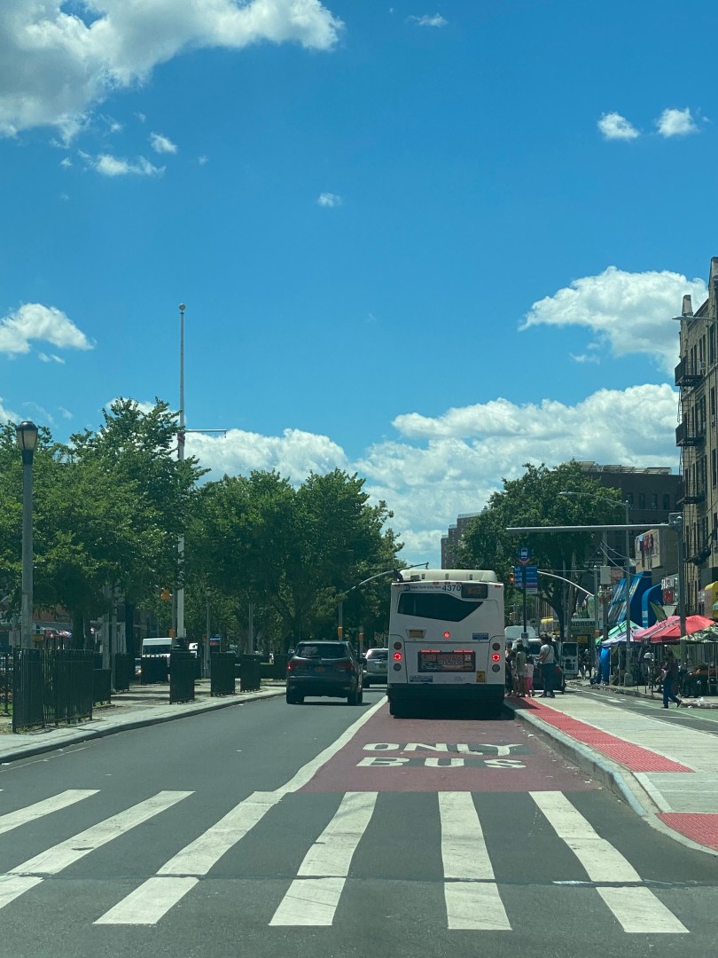
                  Given the amount of riders who need to get in, out and around Downtown Flushing daily, fast and reliable service is imperative to get riders where they need to go. Even for riders who take buses outside of Downtown Flushing, traffic in Downtown Flushing and on the Main St corridor can still delay the buses they ride from getting to them, leading to delays for riders who do not even travel in the vicinity of the corridor. Unfortunately and unsurprisingly due to the high density of the neighborhood, buses in  Downtown Flushing on the Main  St/Kissena Blvd were known for being slow and unreliable with bus speeds of below 4 mph on weekday morning rush hours, below 3 mph midday and PM hours on buses that only operated on Main St, for buses that operated on both Main St and Kissena Blvd, bus speeds were 4.8 mph during the AM peak and below 4 mph during the midday and PM peak periods.

    This is why the NYCDOT and MTA implemented the Main St/Kissena Blvd Busway a part of the citywide Better buses initiative in order to get buses moving faster, ease congestion and help hundreds of thousands of riders to get to their destinations reliably.  Even though bus speeds may still not be very high, they have greatly improved and helped the cause to ease the load on one of the central arteries in the Queens Bus Network. The busway is also active 7 days a week, which is reflective of the need for faster buses during off-peak periods.  According to the NYCDOT, as of April 2021, bus speeds are faster at all times of the day in the northbound direction. Bus speeds from Kissena Blvd/Sanford Ave to Main St/Northern Blvd by 22% in the midday and 29% during the PM Peak period. From Main St/Sanford Ave to Main St/Northern Blvd bus speeds have increased by 13% in the midday and 12% in the PM Peak period.


Read More »