Rosebank is a residential community on the East Shore of Staten Island. The neighborhood is directly adjacent to major thoroughfares such as Hylan Blvd and Bay St that connect residents to communities around Staten Island and even the region Additionally, Rosebank is just a 10 minute drive from the Staten Island Ferry and even closer to other busier neighborhoods such as Stapleton and Tompkinsville. The community is also adjacent to the Verrazano Bridge, providing seamless vehicular and transit connections to Brooklyn.
Midtown Manhattan is arguably the commercial, cultural and recreational hub of both New York City and the World. Many prominent corporations have headquarters in Midtown such as JPMorgan Chase, Calvin Klein and Marvel to name a few. Midtown is also a hub for the entertainment industry, with Broadway Theatre and other performing arts venues attracting millions from around the world annually. Additionally, Midtown is known for a slew of other tourist attractions that attract millions of yearly visitors each such as St. Patrick’s Cathedral, Times Square, and Rockefeller Center. If that is any indicator, Midtown is well traversed by both locals and tourists alike.
While Midtown is the hub of many things, it is not the hub of government offices. The headquarters and offices of most government agencies in New York City tend to be concentrated in Lower Manhattan and Downtown Brooklyn. However, the MTA was once an exception, with their headqaurters on Madison Avenue between 44th and 45th Streets at 343 Madison Ave. Between 1998 and 2014, much of MTA operations were decentralized with many employees at their current Financial District headquarters, the Madison Avenue location, and another site at 370 Jay Street in Downtown Brooklyn. However, the latter two sites were closed due to financial difficulties and a desire for the MTA to consolidate office operations. Hence, workers at both buildings have since moved to the Financial District office at 2 Broadway just outside the Bowling Green(4,5) subway station. The Brooklyn site is now home to the NYU Center for Urban Science and Progress(CUSP).
Current MTA Headquarters at 2 Broadway(light blue building) as seen from boat in New York Harbor.
As for the Madison Avenue HQ, this site has had a more tumultuous story since its closure. Upon closing the building, the MTA looked for a developer to redevelop the property and generate revenue for the often cash-strapped transit agency. In 2020, the MTA chose Boston Properties out of nine potential bidders in order to redevelop the site. Properties owned by the developer include the Times Square Tower where the main entrance to the Times Sq-42nd St station is located, Dock 72 in Brooklyn, and many other buildings in Midtown Manhattan. However following the deal, there was a dispute between the MTA and former NYC Mayor Bill de Blasio between how the money would be shared between the transit agency and the city in the form of property taxes. The mayor had touted the proposed redevelopment as made possible by his East Midtown Rezoning, which included provisions for taller buildings like the one that was eventually proposed for the site. Ultimately, the parties reached a compromise that involved $600 million in revenue being counted toward the city’s $2.66 billion contribution to the MTA’s 2015-19 Capital Plan. The redevelopment will now generate over $1 billion for both the city and MTA.
After 7 years of being abandoned, the City Council finally approved plans for a 55-story office skyscraper that has since been scaled down to 49 stories. In addition to adding yet another building to the city’s iconic skyline, the building will include retail and underground connections to Grand Central Terminal. Despite the boom of hybrid work, workers are increasingly headed back into NYC offices. According to a study by The Partnership for New York City, 58% of Manhattan office workers were working in-person post-Labor Day 2023. That was up from 52% in late January and 49% in September 2022. As many prefer hybrid work due to commute times, 343 Madison Avenue will be a very desirable office location due to its direct connection to Grand Central Terminal, especially with the new Grand Central Madison being fully operational. Additionally, many workers will almost certainly be more inclined to work in a newer building with modern amenities than they would in one of East Midtown’s other buildings whose average age is more than 70 years old.
In addition to adding offices, the new development is one of many projects that will help East Midtown stay competitive as a core business district. As other areas of Midtown grow and more jobs are located in the outer boroughs, having desirable facilities in East Midtown is imperative to bringing more business in the neighborhood. Many of East Midtown’s current buildings are less attractive to corporations due to flaws such as low floor to ceiling heights and a multitude of interior columns. Some office buildings with these issues were even converted to hotels pre-pandemic such as the Marriott Courtyard at 866 Third Avenue, the Library Hotel at 299 Madison Avenue, and the Condominiums at 5 E 44th St. This is why the city rezoned the neighborhood in 2017 to address these issues and usher in new development that would make companies continue to want East Midtown space. The rezoning was also done to help take advantage of the opportunities created by projects such as Grand Central Madison and a possible extension of the Second Avenue Subway south of 72nd St in the future. The 343 Madison Ave project is just one of several that will contribute to the rezoning’s goal.
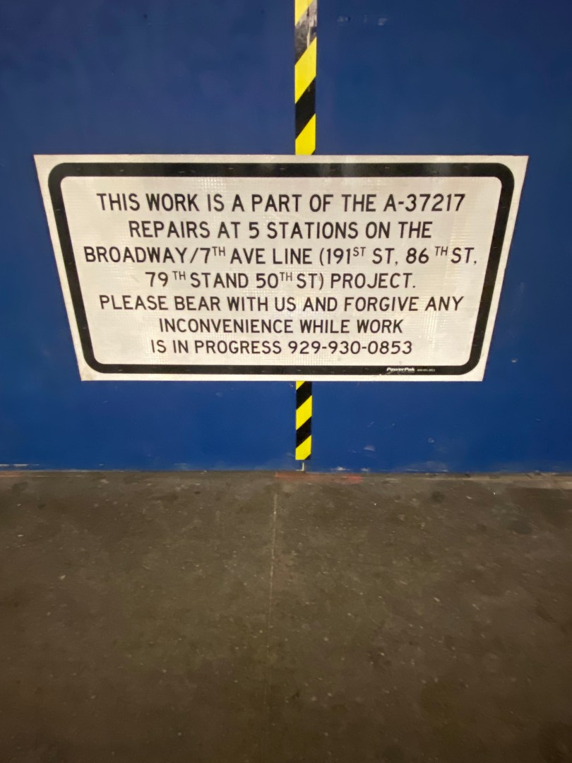
The new skyscraper is scheduled to be completed by 2026. Before construction can start, the demolition of the former MTA HQ that is nearing completion must be finished. The demolition, which has been ongoing since 2022, is likely not finished due to the complexity of demolishing such a large structure. When a structure is demolished, many steps must be taken to ensure the safety of the surrounding community and that hazardous materials such as asbestos are not leaked into the air. The hazards associated with asbestos are part of why many people who lived or worked near Ground Zero following the 9/11 attacks contracted asbestos-related cancers. Due to environmental concerns and surrounding buildings, the building cannot just simply be imploded. Even the use of a wrecking ball would likely be unfeasible due its tendency to swing past its intended targets, which could spell disaster in a place as dense as Midtown. In fact, wrecking balls and implosion are not permitted anywhere in NYC likely for these reasons.
Signage indicating demolition at 343 Madison Ave.Part of former MTA HQ that is being demolished at 343 Madison Ave.Part of former MTA HQ that is being demolished at 343 Madison Ave.
As demolition continues, it is unclear if construction on the skyscraper will be delayed as the average skyscraper takes about 2-10 years to build. On top of that, New York builds skyscrapers at a significantly lower rate than other U.S cities. This may make some New Yorkers skeptical of the 2026 completion timeline. The MTA has $15M in its 2020-24 Capital Plan earmarked for added costs connected to the demolition and sale of 343 Madison Ave. This initiative is scheduled to end in June 2025 and it is not clear what specific costs the agency is referring to. However, the “sale” might refer to Boston Properties selling a 45% stake in the property to an undisclosed investor though its still unclear what role the MTA had or world have had in the sale.
While the construction status of the building may be uncertain, the future for 343 Madison Avenue is definitely bright. As we are just a few years past wondering if workers would ever enter offices again, projects like office buildings remain prevalent in our society. It is also part of NYC’s tremendous economic comeback which has seen private sector employment exceed pre-pandemic levels. As sitework continues, this project will undoubtedly set the table for tremendous growth in East Midtown on the land previously occupied by the agency that keeps New York City moving.
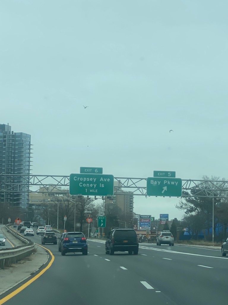
The Belt Parkway is one of the most utilized highways in New York City. Spanning roughly 25 miles, the Parkway runs from the Bay Ridge section of Brooklyn, to the Queens/Nassau County border. With this length, the parkway provides many regional connections such as to Ocean Pkwy, I-678(Van Wyck Expwy), the Southern State Pkwy and of course to I-278(Gowanus Expwy/Verrazano Bridge). The parkway also provides direct access to JFK Airport, New York’s main international airport and Coney Island, a regional recreation hub. In addition to connecting the region, the parkway provides access to many densely populated communities throughout Brooklyn, Queens and Staten Island. While much of New York relies on mass transit, most communities along the Belt have car ownership rates above 50%. Hence, more residents of surrounding communities rely on the Belt Parkway to get around versus residents around other highways in the city such as the FDR Drive and Bruckner Expressway.
As a result, it is no wonder that the Belt Pkwy is among the most congested highways in New York City. While there are many factors to the congestion in different areas, the eastbound side of the highway just off the Verrazano Bridge is definitely one of them. This is in part because the number of lanes on the Belt suddenly drop from three to four with the bridge merging onto the parkway, leading to bottlenecks. This creates a chain reaction that impacts drivers across the Belt regardless of where they are going. In addition, it costs motorists significantly in fuel. According to The Zebra, driving two miles on the Belt Pkwy East near the Verrazano during the Monday AM Peak with the fuel efficiency of a typical new car costs $0.26 each time or $6.50 over 25 days. Given how the calculator doesn’t take congestion into account and many drive less fuel efficient vehicles, the cost per driver in the AM peak is likely higher.
To help reduce congestion and increase vehicular safety, the MTA is adding a fourth lane to the Belt Pkwy between merge between the bridge and the parkway and Exit 5-Bay Pkwy. While the NYSDOT(New York State Department of Transportation) controls most highways, the MTA is likely performing this project due to its connection to the Verrazano Bridge, which is MTA owned. The agency says that the project will “improve traffic flow and reduce back-ups and collisions” in the project description on its Capital Plan Dashboard. As construction has been going for quite some time, the project is 15% complete and is expected to be completed by the end of this year. Additionally, the project is expected to be nearly 50% under budget with a cost of $40.4 million versus the originally budgeted $82 million.
Belt Pkwy near Bay Pkwy in which the MTA is widening. Picture taken 12/11/2022.Belt Pkwy near Exit 5-Bay Pkwy. Picture taken 12/11/2022.
Despite the MTA’s claims, not everyone is convinced the lanes will help improve travel conditions. Transit advocates feel that this will ultimately lead to increased congestion due to induced demand. Induced demand is when traffic increases because more people choose to drive once a roadway is widened. These advocates also believe that the project will further harm the environment and that the MTA should focus on other mass transit investments to combat climate change. Liam Blank of the Tri-State Transportation Campaign told amNewYork Metro, “If we’re going to be serious about addressing climate change, then we should put our money where our mouth is and encourage fewer people to drive.” Even some motorists were skeptical that the project won’t reduce congestion much in the long term. When asked if the extra lane will help before construction started, one motorist told CBS 2 New York’s Ali Bauman simply “It won’t help.”
So will the new lane improve congestion or should the MTA try other things? It is important to note that the lane is not being added to solely improve capacity, but also safety. Typically, the word “induced demand” is used to describe increases in congestion due to highway widening projects that were completed solely to improve congestion on an overcrowded highway. Examples of this include the Katy Freeway widening outside of Houston, TX and Interstate 405 in Los Angeles, CA. However, this project on the Belt is to eliminate traffic caused not by capacity constraints, but by the merge. If the bottleneck is eliminated, safety will improve as there will no longer be a conflict for road space regardless of what ultimately happens with congestion levels. As for congestion however, traffic flow will undoubtedly improve as vehicles would no longer have to slow down or even queue to proceed through. Even if initial congestion improvements are not sustained, the lane will definitely make driving in this portion of the Belt Pkwy easier and possibly faster for the long term due to a simpler traffic pattern.
Given the history of induced demand, is worth wondering if more people will use the Belt Pkwy because of the added lane and lead to more congestion overall. While induced demand is a thing, it is not a hard and fast rule every time a highway is widened. As for the Belt, the project near the Verazzano will likely have no significant impact on the Belt Pkwy’s congestion as a whole for all 25 miles. Hence, the extra lane probably won’t encourage many people to drive who would not have driven otherwise. The primary way congestion would increase there would be more vehicles and hence traffic congestion following the lane’s construction is due to population and/or car ownership growth. In this case, the lane would help so that more vehicles can be accommodated safely regardless of congestion levels.
Outside of the lane, there may be other solutions that can help work to reduce congestion on the Belt. While a CBS New York report from 2021 regarding the Belt discussed congestion pricing, congestion pricing likely won’t impact the Belt Pkwy much. This is due to the Belt going from east to west and not connecting to any Manhattan-bound highways except at its western end. To allveiate congestion, the MTA may want to consider expanding transit options between Staten Island and parts of Brooklyn along the Belt Pkwy. Currently, in order to get from the Rosebank section of Staten Island near the Verrazano Bridge to Gravesend in Brooklyn, it could take well over an hour and includes two buses. One of these buses, the B1, had a Customer Journey Time Performance rate of 71.3% with an average speed of 6.9 mph in December 2023 according to MTA metrics, making the bus substantially less reliable than driving. Getting to other parts of Southern Brooklyn require even more arduous commutes and getting to Queens could feel almost impossible. Queens-bound trips from Rosebank would requiring an express bus trip into Manhattan, followed by the subway and even an additional bus depending on the destination. Hence, better transit options could included expanded and more reliable bus networks and possibly ferry service between waterfront areas. Thanks to the NYC Ferry, many areas of the city are connected by mass transit that weren’t before the ferry such as Soundview, Bx/Lower East Side, Manh and St. George, SI/Midtown, Manh.
Outside of expanding transit options, the MTA could consider higher Verazzano Bridge tolls during rush hours or higher tolls altogether to discourage nonessential travel. This would be similar to how congestion pricing is beinging implemented in the Manhattan Central Business District where there will be lower tolls at night. However, this idea would almost surely be struck down by Staten Islanders whom the bridge is their only road connection to the other boroughs of New York City. Additionally, with the burden congestion pricing in Manhattan will already have on motroists, the MTA likely does not want to add or increase more tolls in an unpopular way. As it stands, a Staten Island resident driving to Manhattan will have to pay $24.69 to drive one-way into Manhattan between the Verazzano Bridge, Brooklyn Battery Tunnel and Congestion Pricing tolls. Thus, any additional costs would likely not be taken kindly to by motorists.
As the MTA moves forward with the project, it will be interesting to see how the parkway widening will effect Brooklyn-Staten Island commuters. According to the MTA Capital Plan Dashboard, the project is 15% complete and is expected to be done by the end of the year. Also, the project is expected to be nearly 50% under budget with a cost of $40.4 million versus the originally budgeted $82 million. Compared to the rest of the U.S, this project sparked a conversation about the impacts of highway widening that is not had often in New York. Hopefully, the MTA finds solutions that reduce congestion, increase safety and enable reliable regional travel for years to come.
In New York City, much of the population relies on mass transit run by the MTA(Metropolitan Transportation Authority)to get around. According to data from the NYC Department of City Planning, only 46% of city households own a car. Even vehicle owners often use mass transit to get to Manhattan due to traffic congestion and high parking costs. Additionally, hundreds of thousands of riders from outside of the city ride the Metro-North and LIRR commuter rails to get around the suburbs as well as into the city daily. Given how many people it moves, the MTA also plays a major part in New York’s economy. An NYU study from October 2020 found that a 40% reduction in bus/subway service and a 50% reduction in commuter rail service would cost riders more than $1.7 billion in lost time each year. This is only reflective of the impact of transit service reduction and does not reflect the impact of if mass transit were to not exist at all.
Roadways in New York City and its suburbs are notorious for its congestion during rush hours. While many New Yorkers ride public transit to work, about 50% drive according to a Bloomberg article from 2019. Despite high transit use in the region, five New York area highways cracked Yahoo Finance writer Zarah Hamid’s top 20 most congested highways in America list. This included several major thoroughfares such as the George Washington Bridge and Long Island Expressway.
The Borough of Manhattan is by far the most transit-dependent place in the United States. Given its status as the cultural and commercial hub of New York City, mass transit is essential to ensuring that people in Manhattan can get around quickly and reliably. As subways are faster than buses, most New Yorkers ride the subway when traveling in Manhattan. According to data from the NYC Department of City Planning, only 23% of Manhattan households have access to a car. Hence, public transportation is essential to the mobility of most Manhattanites. Even those that do own a car often do not drive within the borough due to Manhattan’s sheer congestion coupled with lack of street parking. Outside of residents, many from around the NY Metropolitan area enter Manhattan for work, recreation and other purposes on any given day. With how many people enter Manhattan coupled with its notorious gridlock, mass transit is truly essential to alleviating congestion.
New York City is the largest city in the United States and is the nation’s cultural, commercial and financial center. Thanks to its vast public transit system, New Yorkers are able to traverse the city without the use of a car and avoid traffic. Given how hard it can be to drive in the city, riding transit allows you to notice things about your surroundings that you just wouldn’t if you were behind the wheel. There are many institutions that everyone knows about, such as the Statue of Liberty, Museum of Natural History or Broadway Theatre to name a few. However, there are many significant places don’t get that immediate recognition. In this series, I will highlight many of these places and share the history and significance of them. I am also going to discuss how public transit has contributed to the locations’ history as well as the surrounding community. I hope that this series can help to spread awareness of the importance of transit to life in New York and how transit has truly shaped what the city has become. Join me for the ride.
The most notable destination in the Willets Point neighborhood in Queens is undoubtedly Citi Field, home of the New York Mets. Despite most considering Citi Field part of Flushing, the stadium sits entirely in Willets Point according to Google Maps. Additionally, both the subway and LIRR stations adjacent to the stadium are both named Mets-Willets Point.
Tremont Avenue in The Bronx is one of the busiest east-west streets in the borough. In addition, it is one of The Bronx’s longest streets at about 7 miles between the Throggs Neck and Morris Heights neighborhoods. The street crosses the entire borough and connects to several other major corridors such as White Plains Rd, Third Ave, and University Ave. Tremont Ave also runs parallel, to the Cross Bronx Expwy, which provides drivers an alternative to one of the most congested highways in the Northeast. In addition, Tremont Avenue provides access to several major destinations such as the River Park Towers and Crotona Park. Every subway route in The Bronx has a stop on or within a 3 minute walk of Tremont Ave. Additionally, Tremont Ave is served by the Metro-North’s Harlem and New Haven Lines at the Tremont Station. As for buses, Tremont Ave is served by the Bx40, Bx42 and Bx36 routes, that provide connections to various communities across the Bronx with the Bx36 going to Washington Heights, Manhattan.
As you can imagine, Tremont Avenue is known for its congestion that leads to slow travel speeds especially for bus riders. Tremont Avenue is especially known for slow bus speeds between University Avenue and Boston Rd. During rush hours, buses average speeds of less than 5 to 8 mph in most sections in both directions. As 29,000 ride the bus through here daily and 72% of nearby residents do not own a car according to the NYCDOT, bus service here is critical to people getting around. Unfortunately, Tremont Avenue’s high volume also in part contributes to safety risks. Between 2016-2020, 1,100 were injured in crashes on Tremont with 215 of them being pedestrians. The intersections of Tremont Ave and the Grand Concourse, Anthony Ave and Boston Rd are considered Vision Zero Priority Intersections respectively.
Due to the slow bus speeds and safety conditions, the New York City Department of Transportation(NYCDOT), is developing a plan to improve Tremont Ave between Boston Rd and University Ave for all road users. The agency has already taken several steps in order to so. In 2016, the agency added a combination of traditional and shared bike lanes, curb extensions and better lane markings for the purpose of improving safety for cyclists between Boston Rd and Tremont’s western terminus at Sedgwick Ave. As for bus speeds, the MTA and NYCDOT proposed adding Select Bus Service to Tremont as part of the 2017 Bus Forward Plan. This would have included the addition of off-board fare collection and likely bus lanes. There has been no discussion of SBS implementation during the recent Bronx Bus Network Redesign or the NYCDOT’s current project.
As for what the NYCDOT’s current plans are, it seems like anything is on the table. In their recent presentation to Bronx Community Advisory Board 1, they showed their transit toolkit which included everything from curbside bus lanes to transit-exclusive busways. In addition, they demonstrated bus boarding islands and pedestrian islands that could help shorten crossing distances for pedestrians and have them wait for the bus in safer places. They also presented ways to make the bus stop more comfortable for riders, through means like benches and leaning bars.
Given how slow buses on Tremont, it would not be surprising to see the NYCDOT propose almost any of the street additions they presented to the Community Advisory Board. The most significant change, a busway, is already in place on the nearby 181st St in Washington Heights. The nearby Fordham Rd in The Bronx , was also slated to get a busway, but it was nixed due to opposition from local businesses and the lack of alternatives for drivers could have resulted in gridlock conditions of nearby side streets. As busways have usually only been on the absolute slowest corridors, a busway on Tremont Ave does seem to be unlikely. While Tremont’s speeds are as slow as some busway corridors have been in some spots, it is just not as consistently slow as corridors like 181st St have been. Busways are likely saved for the slowest corridors due to opposition they have received in nearly each instance from drivers and businesses due to the inability to drive and park on the corridor. As cars often double park to access the various retail stores on Tremont, a busway will likely not sit well with many road users.
Several cars double parked on a Sunday Afternoon at E Tremont Av/Mapes AvMultiple cars parked in bike lane on E Tremont Av/Crotona Av
While a busway may not work, the NYCDOT will almost certainly propose some sort of bus lane for the corridor. A center running bus lane is likely unfeasible as the corridor is not as wide as those such as E 161st St where center running lanes have been implemented. However, an offset or curbside bus lane definitely has a significant chance of being proposed. A curbside lane is exactly what it sounds like while an offset lane, is the use of the rightmost travel lane as a bus lane. Both may generate opposition from drivers due to either the loss of road space or parking space depending on which setup the NYCDOT wants to go with. Regardless, the NYCDOT will likely go with the curbside lane due to the street having only one travel, parking and in some parts a bike lane in each direction. In a presentation to Manhattan Community Board 3 regarding another bus improvement project, the agency said that curbside bus lanes were reserved for narrower corridors while offset bus lanes are set for corridors with more space. Therefore, this is likely the NYCDOT’s best chance at striking a balance between the needs of motorists and bus riders.
Tremont Avenue at Prospect Ave with one travel lane and one bike lane in each direction.
Outside of bus lanes, the NYCDOT is considering adding Transit Signal Priority(TSP) to Tremont so that buses either have extended or early green lights so that buses could proceed faster through intersections. This could definitely be helpful as TSP on five busy routes citywide sped up buses by an average of 18% according to NYCDOT data. Additionally, the NYCDOT and the MTA have already worked to install ABLE cameras on the Bx36 route that runs along the corridor due to enforce the bus lanes and busways respectively on University Ave in The Bronx and 181st St in Manhattan. Even without Tremont Ave bus lanes, the cameras already help improve reliability on Tremont Ave by but it already helps improve overall reliability on Tremont Ave by preventing the bus from being late to Tremont Ave riders due to congestion in other areas.
In regards to bus stops, any of the items in the NYCDOT’s toolkit are likely feasible at most stops along the corridor. In some cases, benches and leaning bars may be subject to spatial constraints, but they nonetheless could become a common sight. The most significant obstacle to getting bus stop upgrades will almost certainly be the city’s budget cuts, initiated by Mayor Eric Adams due to the migrant crisis among other issues. The cuts have even gotten to the point where the New York City Department of Parks and Recreation is maintaining less trash bins and cutting back substantially on park cleaning and maintenance. Given the NYCDOT’s commitment to street improvement projects across the city despite the cuts, small bus stop upgrades will likely not be the agency’s priority.
In addition, most of the NYCDOT’s pedestrian toolkit should be able to come in handy. While bus boarding islands may be difficult due to spatial constraints, smaller pedestrian islands could help to reduce crossing distances and improve safety. Data from the Federal Highway Administration shows that these islands can help to reduce pedestrian crashes by 32%, indicating their effectiveness. The NYCDOT is also considering left and right turn bays at select intersections for drivers to make their turns. Left turns are notoriously dangerous as they involve drivers turning at a higher radius and speed coupled with crossing oncoming traffic. A 2016 study from the NYCDOT shows that left turn bays reduced pedestrian and cyclist injuries by 15%, meaning these bays could help to save lives on the road.
All in all, the NYCDOT’s decision on what to implement on Tremont Ave will likely depend on the needs of the community as well as the risks and benefits of each decision. As the corridor varies in population and commerical density, the NYCDOT broke it into five sections to determine which solutions fit best in each area. This may mean bus lanes or certain types of bus lanes in some spots or not others. This could also determine which pedestrian safety additions are pertinent to which intersections. Since most major decisions will include maintaining space for motorists or adding space for buses and pedestrians, any choices will likely not make everyone happy. The fact that people frequently access Tremont Ave by all modes will make these decisions even more difficult. As the NYCDOT is looking to make large scale improvements, hopefully they come to a solution that benefits all road users for years to come.
New York City Department of transportation. “DOT Press Releases – DOT Releases Status Report on “Transit Signal Priority” Technology Used To Speed MTA Buses.” NYC.gov, 24 July 2017, https://www.nyc.gov/html/dot/html/pr2017/pr17-055.shtml. Accessed 30 December 2023.
The Hartsdale Metro-North(MNR) station on the Harlem Line is the main commuter rail station serving the Hamlet of Hartsdale with a population of 2,964 residents according to Niche.com. The station is also the closest station for some Scarsdale residents, given its proximity to the Scarsdale Town Line. In addition to being a major transportation asset for the community, the station is also on the National Register of Historic Places.