By Joseph Morales
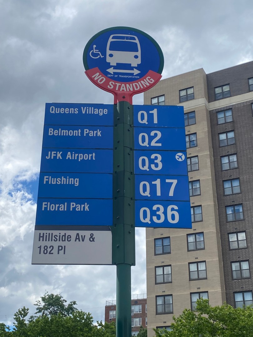
Hillside Avenue travels from east to west is among the busiest streets in Southern Queens. It’s western terminus is at Myrtle Ave, which provides access to Brooklyn and some if its busiest neighborhoods. From there, Hillside Ave travels east into Nassau County, where it connects to the Jericho Turnpike in Westbury. In Queens, a whopping 21 combined MTA and NICE bus routes run on the corridor, serving 194,000 riders daily. NICE is Nassau County’s public bus system. The ridership number for Hillside Ave buses is higher than that of the G Train, which served 70,453 riders in 2023.

Unfortunately, buses on Hillside Avenue are among the slowest in Queens. According to data from the New York City Department of Transportation(NYCDOT), bus speeds are sometimes as low as 4 mph during rush hours. While there are some bus lanes, they are inconsistent, lack clear signage and markings, and they only operate during rush hours in the peak direction. Slow bus speeds are an important issue as 60% of those who live near Hillside Ave between Queens Blvd and Springfield Blvd travel via public transit. Additionally, 40% of area residents do not have access to a vehicle at all. Hence, faster bus speeds are critical to ensuring that those who live in Southern Queens can reliably travel to different places across the borough. As most residents lack walking access to a subway station, the bus is also critical to ensuring that residents can travel to Manhattan along with other key destinations throughout the city. In addition, many Hillside Ave buses provide access to Downtown Jamaica, one of NYC’s busiest shopping and commercial destinations outside of Manhattan.

In addition to slow buses, pedestrian/motorist safety is also a major issue on Hillside Ave. Based on NYCDOT data, 992 people were injured in Hillside Ave crashes between 2018-2022, with an average of almost four injuries per week. Of these 992, 58 people were severely injured, and two were killed. This street is a Vision Zero Priority Corridor with two Vision Zero Priority Intersections at Springfield Blvd and 197th St. On and around Hillside Ave, there are about eight elementary schools and six high schools. There is also a plethora of commercial activity along the corridor, along with four subway stations on the corridor’s western end. Hence, safe pedestrian/driving conditions are essential to ensuring those of all ages and abilities can access Hillside Ave and its surrounding areas safely.
For these reasons, the NYCDOT is planning to redesign Hillside Avenue in order for it to better meet the needs of all road users.
The agency is considering two approaches to speeding up buses. They may pick one or choose a combination of the two in different areas. One is center-running bus lanes, which run down either the median of the street or the leftmost lane. The other is an offset bus lane where the bus lane is next to the parking lane on both sides of Hillside Ave. Under either proposal, the bus lanes would be painted, making them much more visible to drivers. This is critical to the lane’s success as most existing lanes on Hillside are unpainted. These lanes are marked by either all-white “ONLY BUS” lettering and/or small signs that are easy for motorists to miss.
Also being considered under either scenario is extending bus lane hours to 24/7 rather than peak hours in the peak direction. This would be a game-changer for those who reverse commute and travel during off-peak hours, as travel in both directions is common on Hillside at all times of the day. According to NYC Department of City Planning data, 90,000 Queens residents reverse commuted between Queens and Long Island in 2017. As many Hillside Ave buses go to different destinations in Nassau County, faster buses on Hillside Ave East in the reverse-peak direction is crucial for commuters. Outside of reverse commuting, many traverse Hillside Ave in both directions for school, shopping, and a plethora of other purposes.
Whether or not the bus lanes run along the median or are offset likely depends on various factors. There are pros and cons to both setups, and there will likely be disagreements amongst various road users regarding what’s best for everyone on the corridor.
Center-running bus lanes provide the most space for buses and take up no car parking. However, center-running lanes can also result in the removal of car travel lane(s). As many road users on Hillside Ave may come from areas with sparse mass transit options of any kind, some motorists will likely oppose the removal of much of their traffic space. There are five corridors that have substantial center-running bus lanes in NYC. They are E 161st St and Edward. L Grant Hwy/University Ave in The Bronx, Woodhaven Blvd and Merrick Blvd in Queens, and Kings Hwy in Brooklyn. Two of those, Kings Hwy and Woodhaven Blvd, are wide boulevards with a main road and service road, with the bus lanes being the innermost of multiple lanes within the main road. The other two in The Bronx are in communities where car ownership rates are extremely low. While many take transit on Hillside, there is still a much higher proportion of motorists in the surrounding areas than near the bus lanes in The Bronx. Also, despite Hillside Ave being wider than most streets, it is not nearly as large as Woodhaven Blvd or Kings Hwy in areas with center-running bus lanes.
As for offset bus lanes, they are good for prioritizing buses on streets while also allowing vehicle parking. The importance of vehicle parking is evident in the NYCDOT’s proposals for the corridor, as they are not considering curbside bus lanes. Offset bus lanes offer similar, albeit slightly more minor bus speed improvements to curbside lanes without taking any parking at all. Hence, offset bus lanes would likely make the most sense for Hillside Ave due to the amount of motorists it serves. While this will lead to a loss in travel space, many motorists may switch to transit or take alternate routes to avoid traffic. As a result, an offset lane should have limited adverse effects on motorists. In the busiest areas where buses are the slowest, however, the NYCDOT may still consider the center-running lanes.
Outside of bus lanes, the NYCDOT may consider Transit-Signal Priority(TSP) along the corridor. TSP allows for buses to get either an early or extended green in order to move faster. In areas with offset bus lanes, buses may even have bus-only traffic signals allowing them to get a headstart on the rest of traffic. The NYCDOT may also work with the MTA to have ABLE or Automated Bus Lane Enforcement installed on Hillside Ave buses after bus lane construction. This form of camera enforcement has resulted in a 5% increase in bus speeds where it has been implemented according to Streetsblog.
When it comes to pedestrian/motorist safety, the NYCDOT has an array of measures it has and could continue to implement on different sections of Hillside Ave to make the street safer. These include street features such as pedestrian islands and curb extensions that increase pedestrian space and decrease crossing distances. According to NYCDOT statistics, curb extensions reduce injuries by 14.27% along with deaths and serious injuries(KSI) by 44.19%. As for pedestrian islands, those offer a smaller but still significant 7.23% drop in injuries and 34.76% reduction in KSI. While these improvments could occur throughout the corridor, the NYCDOT is likely to prioitize shortening crossing distances near schools for the city’s youngest pedestrians.
In addition to added space, the NYCDOT may also do things to increase the safety of left turns, which account for over 22% of car crashes in the United States accoridng to NHTSA data. This can be done through turn calming mechanisms such as left turn bays where motorist have to turn in a specific lane. Like the other tactics discussed, they are highly effective, resulting in a 17.73% drop in total injuries and a 33.43% in KSI.
While any of these safety improvements could occur throughout the corridor, the NYCDOT is likely to prioitize shortening crossing distances near schools for the city’s youngest pedestrians.
To see which bus and pedestrian improvements work best on Hillside Ave, the NYCDOT will likely continue conducting traffic analysis through various means such as site visis and data collection. They also have an online survey for Hillside Ave bus riders, pedestrians and motorists to discuss their trips along the corridor. The survey asks questions such as how people get to Hillside Ave and how long it takes them to get to their destinations. It also asks about the major issues with certain modes of travel. To participate in the survey, click here:bit.ly/4cFuJvQ. For example, the survey asks bus riders if they experienced things such as a slow ride, long waits, or crowded buses. It also asks motorists how long it takes them to park and how far from Hillside Ave they get spots. The survey is being advertised on QR-code flyers at Hillside Ave bus stops. Using all the info they gather from their various analyses, the NYCDOT plans to have a final redesign proposal for Hillside Ave at some point this Summer along with a revised and likely final plan by the Fall.
With how important Hillside Ave is for Queens, the Hillside Ave redesign will likely have an immense impact on how people travel throughout the borough. Given the multimodal travel nature of Hillside, finding a proposal that works for everyone will not be easy and there is a chance that not everyone will be happy with the proposal that is made. Hopefully, the NYCDOT reaches a solution that speeds up buses and keeps road users safe while causing as little disruption as possible to vehicle traffic. This balance will ensure all road users can use Hillside Ave as seamlessly as possible in order to keep Southern Queens moving.
Works Cited
Duggan, Kevin, and Sophia Lebowitz. “SMILE! Bus Lane Cameras Reduce Collisions, Speed Commutes, MTA Says – Streetsblog New York City.” Streetsblog NYC, 25 April 2023, https://nyc.streetsblog.org/2023/04/25/smile-bus-lane-cameras-reduce-collisions-speed-up-commutes-according-to-mta-stats. Accessed 12 June 2024.
Kavanaugh, Michael. “Why Left-Turn Car Accidents Are So Dangerous.” mkplc, 8 September 2023, https://www.mkplc.com/why-left-turn-car-accidents-are-so-dangerous/. Accessed 12 June 2023.
Kuntzman, Gersh, and Charles Komanoff. “EXCLUSIVE: Despite COVID, DOT Really Stepped Up Transit Signal Priority This Year – Streetsblog New York City.” Streetsblog NYC, 9 October 2020, https://nyc.streetsblog.org/2020/10/09/exclusive-despite-covid-dot-stepped-up-transit-signal-priority-this-year. Accessed 12 June 2024.
Metropolitan Transportation Authority. Annual Subway Ridership(2018-2023). 2023. Accessed 12 June 2024.
Metropolitan Transportation Authority, and New York City Department of Transportation. “Hillside Avenue, Springfield Boulevard to Queens Boulevard | Queens Community Board 8 | May 2024.” NYC.gov, 23 May 2024, https://www.nyc.gov/html/dot/downloads/pdf/hillside-ave-springfield-blvd-queens-blvd-may2024.pdf. Accessed 12 June 2024.
New York City Department of City Planning. “Car Ownership in NYC.” Tableau, 24 November 2022, https://public.tableau.com/app/profile/dcptransportation/viz/ACSProfiles/Dashboard1. Accessed 12 June 2024.
New York City Department of City Planning. “The Ins and Outs of NYC Commuting – Regional Planning.” NYC.gov, September 2019, https://www.nyc.gov/assets/planning/download/pdf/planning-level/housing-economy/nyc-ins-and-out-of-commuting.pdf. Accessed 12 June 2024.
New York City Department of Transportation. “Pedestrian Safety and Older New Yorkers.” NYC.gov, 2022, https://www.nyc.gov/html/dot/downloads/pdf/pedestrian-safety-older-new-yorkers.pdf. Accessed 12 June 2024.
