
By Joseph Morales
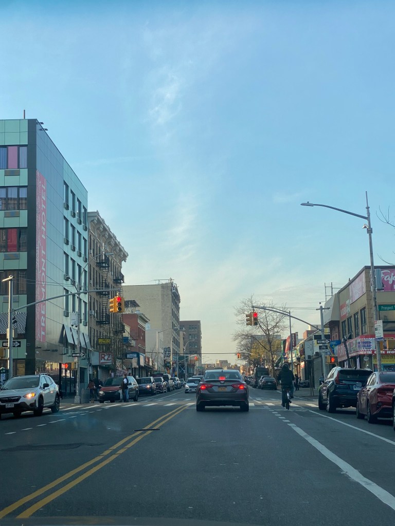
Tremont Avenue in The Bronx is one of the busiest east-west streets in the borough. In addition, it is one of The Bronx’s longest streets at about 7 miles between the Throggs Neck and Morris Heights neighborhoods. The street crosses the entire borough and connects to several other major corridors such as White Plains Rd, Third Ave, and University Ave. Tremont Ave also runs parallel, to the Cross Bronx Expwy, which provides drivers an alternative to one of the most congested highways in the Northeast. In addition, Tremont Avenue provides access to several major destinations such as the River Park Towers and Crotona Park. Every subway route in The Bronx has a stop on or within a 3 minute walk of Tremont Ave. Additionally, Tremont Ave is served by the Metro-North’s Harlem and New Haven Lines at the Tremont Station. As for buses, Tremont Ave is served by the Bx40, Bx42 and Bx36 routes, that provide connections to various communities across the Bronx with the Bx36 going to Washington Heights, Manhattan.
As you can imagine, Tremont Avenue is known for its congestion that leads to slow travel speeds especially for bus riders. Tremont Avenue is especially known for slow bus speeds between University Avenue and Boston Rd. During rush hours, buses average speeds of less than 5 to 8 mph in most sections in both directions. As 29,000 ride the bus through here daily and 72% of nearby residents do not own a car according to the NYCDOT, bus service here is critical to people getting around. Unfortunately, Tremont Avenue’s high volume also in part contributes to safety risks. Between 2016-2020, 1,100 were injured in crashes on Tremont with 215 of them being pedestrians. The intersections of Tremont Ave and the Grand Concourse, Anthony Ave and Boston Rd are considered Vision Zero Priority Intersections respectively.
Due to the slow bus speeds and safety conditions, the New York City Department of Transportation(NYCDOT), is developing a plan to improve Tremont Ave between Boston Rd and University Ave for all road users. The agency has already taken several steps in order to so. In 2016, the agency added a combination of traditional and shared bike lanes, curb extensions and better lane markings for the purpose of improving safety for cyclists between Boston Rd and Tremont’s western terminus at Sedgwick Ave. As for bus speeds, the MTA and NYCDOT proposed adding Select Bus Service to Tremont as part of the 2017 Bus Forward Plan. This would have included the addition of off-board fare collection and likely bus lanes. There has been no discussion of SBS implementation during the recent Bronx Bus Network Redesign or the NYCDOT’s current project.
As for what the NYCDOT’s current plans are, it seems like anything is on the table. In their recent presentation to Bronx Community Advisory Board 1, they showed their transit toolkit which included everything from curbside bus lanes to transit-exclusive busways. In addition, they demonstrated bus boarding islands and pedestrian islands that could help shorten crossing distances for pedestrians and have them wait for the bus in safer places. They also presented ways to make the bus stop more comfortable for riders, through means like benches and leaning bars.
Given how slow buses on Tremont, it would not be surprising to see the NYCDOT propose almost any of the street additions they presented to the Community Advisory Board. The most significant change, a busway, is already in place on the nearby 181st St in Washington Heights. The nearby Fordham Rd in The Bronx , was also slated to get a busway, but it was nixed due to opposition from local businesses and the lack of alternatives for drivers could have resulted in gridlock conditions of nearby side streets. As busways have usually only been on the absolute slowest corridors, a busway on Tremont Ave does seem to be unlikely. While Tremont’s speeds are as slow as some busway corridors have been in some spots, it is just not as consistently slow as corridors like 181st St have been. Busways are likely saved for the slowest corridors due to opposition they have received in nearly each instance from drivers and businesses due to the inability to drive and park on the corridor. As cars often double park to access the various retail stores on Tremont, a busway will likely not sit well with many road users.


While a busway may not work, the NYCDOT will almost certainly propose some sort of bus lane for the corridor. A center running bus lane is likely unfeasible as the corridor is not as wide as those such as E 161st St where center running lanes have been implemented. However, an offset or curbside bus lane definitely has a significant chance of being proposed. A curbside lane is exactly what it sounds like while an offset lane, is the use of the rightmost travel lane as a bus lane. Both may generate opposition from drivers due to either the loss of road space or parking space depending on which setup the NYCDOT wants to go with. Regardless, the NYCDOT will likely go with the curbside lane due to the street having only one travel, parking and in some parts a bike lane in each direction. In a presentation to Manhattan Community Board 3 regarding another bus improvement project, the agency said that curbside bus lanes were reserved for narrower corridors while offset bus lanes are set for corridors with more space. Therefore, this is likely the NYCDOT’s best chance at striking a balance between the needs of motorists and bus riders.
Outside of bus lanes, the NYCDOT is considering adding Transit Signal Priority(TSP) to Tremont so that buses either have extended or early green lights so that buses could proceed faster through intersections. This could definitely be helpful as TSP on five busy routes citywide sped up buses by an average of 18% according to NYCDOT data. Additionally, the NYCDOT and the MTA have already worked to install ABLE cameras on the Bx36 route that runs along the corridor due to enforce the bus lanes and busways respectively on University Ave in The Bronx and 181st St in Manhattan. Even without Tremont Ave bus lanes, the cameras already help improve reliability on Tremont Ave by but it already helps improve overall reliability on Tremont Ave by preventing the bus from being late to Tremont Ave riders due to congestion in other areas.
In regards to bus stops, any of the items in the NYCDOT’s toolkit are likely feasible at most stops along the corridor. In some cases, benches and leaning bars may be subject to spatial constraints, but they nonetheless could become a common sight. The most significant obstacle to getting bus stop upgrades will almost certainly be the city’s budget cuts, initiated by Mayor Eric Adams due to the migrant crisis among other issues. The cuts have even gotten to the point where the New York City Department of Parks and Recreation is maintaining less trash bins and cutting back substantially on park cleaning and maintenance. Given the NYCDOT’s commitment to street improvement projects across the city despite the cuts, small bus stop upgrades will likely not be the agency’s priority.
In addition, most of the NYCDOT’s pedestrian toolkit should be able to come in handy. While bus boarding islands may be difficult due to spatial constraints, smaller pedestrian islands could help to reduce crossing distances and improve safety. Data from the Federal Highway Administration shows that these islands can help to reduce pedestrian crashes by 32%, indicating their effectiveness. The NYCDOT is also considering left and right turn bays at select intersections for drivers to make their turns. Left turns are notoriously dangerous as they involve drivers turning at a higher radius and speed coupled with crossing oncoming traffic. A 2016 study from the NYCDOT shows that left turn bays reduced pedestrian and cyclist injuries by 15%, meaning these bays could help to save lives on the road.
All in all, the NYCDOT’s decision on what to implement on Tremont Ave will likely depend on the needs of the community as well as the risks and benefits of each decision. As the corridor varies in population and commerical density, the NYCDOT broke it into five sections to determine which solutions fit best in each area. This may mean bus lanes or certain types of bus lanes in some spots or not others. This could also determine which pedestrian safety additions are pertinent to which intersections. Since most major decisions will include maintaining space for motorists or adding space for buses and pedestrians, any choices will likely not make everyone happy. The fact that people frequently access Tremont Ave by all modes will make these decisions even more difficult. As the NYCDOT is looking to make large scale improvements, hopefully they come to a solution that benefits all road users for years to come.
Works Cited
Barone, Vincent. “14th Street busway supporters slam block associations’ lawsuit as classist.” amNewYork, 1 July 2019, https://www.amny.com/transit/14th-street-busway-lawsuit-1-33243425/. Accessed 30 December 2023.
Duggan, Kevin. “‘We heard them’: Mayor Adams says ‘community leaders’ wanted 181st Street busway hours cut.” amNewYork, 1 August 2022, https://www.amny.com/transit/mayor-adams-defends-181-busway-community/. Accessed 30 December 2023.
Duggan, Kevin, and Dave Colon. “City Makes Jamaica Busways Permanent But With Shorter Hours; Begins Northern Blvd. Bus Lanes – Streetsblog New York City.” Streetsblog NYC, 15 November 2022, https://nyc.streetsblog.org/2022/11/15/city-makes-jamaica-busways-permanent-but-with-shorter-hours-begins-northern-blvd-bus-lanes. Accessed 30 December 2023.
Federal Highway Administration. “Pedestrian Refuge Island Safe Transportation for Every Pedestrian Countermeasure Tech Sheet.” FHWA Highway Safety Programs, June 2018, https://safety.fhwa.dot.gov/ped_bike/step/docs/techSheet_PedRefugeIsland2018.pdf. Accessed 30 December 2023.
Federal Highway Administration. “Pedestrian Refuge Island Safe Transportation for Every Pedestrian Countermeasure Tech Sheet.” FHWA Highway Safety Programs, June 2018, https://safety.fhwa.dot.gov/ped_bike/step/docs/techSheet_PedRefugeIsland2018.pdf. Accessed 30 December 2023.
Metropolitan Transportation Authority. “MTA Activates Bus Lane Enforcement Cameras Along Bx36 Route in the Bronx and Manhattan.” MTA, 16 June 2023, https://new.mta.info/press-release/mta-activates-bus-lane-enforcement-cameras-along-bx36-route-bronx-and-manhattan. Accessed 30 December 2023.
Nessen, Stephen, and Jessy Edwards. “Judge Clears Way For Flushing Bus Lane Opposed By Local Businesses.” Gothamist, 5 January 2021, https://gothamist.com/news/judge-clears-way-flushing-bus-lane-opposed-local-businesses. Accessed 30 December 2023.
New York City Department of Transportation. “Better Buses for Restart.” NYC.gov, July 2021, https://www.nyc.gov/html/dot/downloads/pdf/m14ad-bus-priority-cb3-jul2021.pdf. Accessed 30 December 2023.
New York City Department of Transportation. “Bus Forward.” NYC.gov, 20 October 2017, https://www.nyc.gov/html/brt/downloads/pdf/bus-forward.pdf. Accessed 30 December 2023.
New York City Department Of Transportation. “DON’T CUT CORNERS-LEFT TURN Pedestrian & Bicyclist Crash Study.” NACTO.org, August 2016, https://nacto.org/wp-content/uploads/2017/11/left-turn-pedestrian-and-bicycle-crash-study-1.pdf. Accessed 30 December 2023.
New York City Department of transportation. “DOT Press Releases – DOT Releases Status Report on “Transit Signal Priority” Technology Used To Speed MTA Buses.” NYC.gov, 24 July 2017, https://www.nyc.gov/html/dot/html/pr2017/pr17-055.shtml. Accessed 30 December 2023.
New York City Department of Transportation. “181st Street Busway – Community Board Advisory Board Meeting – June 23, 2022.” NYC.gov, 23 June 2022, https://www.nyc.gov/html/dot/downloads/pdf/181-st-broadway-ave-amsterdam-ave-jun2022.pdf. Accessed 30 December 2023.
New York City Department of Transportation. “Tremont Ave.” NYC.gov, 21 January 2016, https://www.nyc.gov/html/dot/downloads/pdf/tremont-ave-cb6-jan2016.pdf. Accessed 30 December 2023.
New York City Department of Transportation. “Tremont Avenue Bus Priority Improvements – Community Advisory Board Meeting #1.” NYC.gov, 12 December 2022, https://www.nyc.gov/html/dot/downloads/pdf/tremont-ave-bus-priority-cab1-dec2022.pdf. Accessed 30 December 2023.
New York City Department of Transportation, and Metropolitan Transportation Authority. “Better Buses Restart: Downtown Flushing Main St. Busway – Community Advisory Board.” NYC.gov, 13 April 2021, https://www.nyc.gov/html/dot/downloads/pdf/main-st-flushing-busway-cab4-apr2021.pdf. Accessed 30 December 2023.
Rivoli, Dan. “Transit advocates rally for Fordham Road ‘busway.’” NY1, 11 July 2023, https://ny1.com/nyc/bronx/transit/2023/07/11/transit-advocates-rally-for-fordham-road–busway-. Accessed 30 December 2023.
Weaver, Shaye. “Here’s how the mayor’s budget cuts could affect your local park.” TimeOut, 15 December 2023, https://www.timeout.com/newyork/news/heres-how-the-mayors-budget-cuts-could-affect-your-local-park-121523. Accessed 30 December 2023.
