By Joseph Morales
*To get to information on bike network, either scroll down or press ctrl-f and search :
Most New Yorkers consider Eastern Queens to represent areas of Queens east of the Whitestone/Van Wyck Expressways(I-678). Eastern Queens has a diverse range of neighborhoods, from the bustling business districts of Downtown Flushing and Jamaica, which are among the busiest in the city outside of Manhattan, to the lower-density residential areas of Bayside and Douglaston. Eastern Queens is also among the most ethnically diverse areas of the city, with people from Asia to Latin America and everywhere in between making up a substantial portion of the population.
In addition to its diverse groups of land uses, ethnicities, and businesses, the area has a diverse set of transportation needs and mobility contexts. As densities vary substantially in different parts of this area, different neighborhoods tend to have drastically different levels of car ownership and transit use, with car ownership levels ranging from 60%-92% depending on the neighborhood, according to data published by the New York City Economic Development Corporation(NYCEDC) in 2018. Even in areas of higher car ownership, many use transit to get to Downtown Flushing and Jamaica to get to the subway or the business districts without having to tend with congestion and parking challenges. Nonetheless, traffic congestion is common throughout all Eastern Queens due to high traffic volumes of vehicles attempting to traverse the area daily, with more congestion in the Downtowns and major thoroughfares such as Main St, Northern Blvd, and Merrick Blvd.
To improve congestion and promote active, green modes of transportation, Eastern Queens residents, political leaders, and advocacy groups have called for improved micro-mobility infrastructure over the years to help more people safely get around through active modes such as walking and cycling that can reduce car dependency. Reduced car dependency does not necessarily mean not owning a car; instead, it means being less likely to use it for every trip. Reduced car dependency may help reduce congestion and alleviate parking issues in Eastern Queens communities as, according to a study by transportation data company INRIX, 51% of car trips in New York City are less than three miles, and 22% are less than one mile. While no borough or neighborhood-specific data was available for Queens, more of these shorter trips are likely occurring in areas such as Eastern Queens, where more residents own cars, and the process of driving and parking is less tedious than in Midtown Manhattan.
Thus, the NYCDOT(New York City Department of Transportation) is working on implementing several cycling safety/micro-mobility projects in the area, including introducing an e-scooter sharing program. On June 15th, 2023, the NYCDOT announced that the e-scooter sharing program that has been running since August 2021 in the Eastern Bronx will expand to Eastern Queens in 2024. The boundaries will essentially comprise most of the area colloquially considered Eastern Queens, with the NYCDOT explaining the boundaries as “Flushing and Auburndale to the north down to Rochdale Village and Springdale Gardens to the south.” Like the initial combined pilot area in The Bronx, the areas chosen for the initial Queens expansion have a population of about 600,000 residents. In the NYCDOT press release, City Council Majority Leader and Transportation and Infrastructure Committee Chair Selvena N. Brooks Powers said, “This program will provide clean, efficient, and affordable micromobility options to community members in need. I look forward to working with DOT to ensure the program is rolled out equitably.”
The NYCDOT likely hopes that the program in Queens will build off the smashing success it has experienced in a demographically similar Eastern Bronx minus two major downtowns(Downtown Flushing and Jamaica). Since August 2021, New Yorkers in the East Bronx have recorded over two million trips and 115,470 individual user accounts with the three e-scooter providers in the program(Lime, Veo, and Bird).
For the safety of riders, the NYCDOT required in The Bronx that the three companies involved in the pilot(Lime, Veo, and Bird) provide an in-app safety quiz as well as a “beginner mode” that capped rider speeds at 10 mph for three rides and restricted overnight riding. The NYCDOT mandated a speed limit of 15 mph for all e-scooters regardless of rider experience. Additionally, the providers required that riders be at least 18 years of age or older to ride, and they were required to verify riders’ age via an ID as per DOT regulations. The providers also had to host monthly community events that included free lessons and helmet giveaways. The NYCDOT formed a safety committee to meet with the companies to adjust safety contracts as needed. These safety policies have been considered successful in The Bronx, as there have been no fatalities and few minor injuries; thus, these policies will likely be in place for the Queens expansion as well.
Multiple key similarities and unique challenges could shape how e-scooters are used in Queens. A fundamental similarity between the East Bronx and Eastern Queens is that they both have a similar commercial and residential density, excluding the Downtowns in Queens, along with an extensive network of residential or medium-density streets that make for more ideal scootering conditions. Many also may use it to run errands, get to businesses, or just for fun, just as riders did in The Bronx, according to the NYCDOT’s report on the success of the East Bronx pilot. Given how many car trips in NYC are less than a mile and how more than half of the trips are less than 3 miles, more e-scooter usage could result in lower congestion levels and parking demand.

In addition, as many East Bronx residents use scooters to access subway stations, this will likely be a trend in Eastern Queens as well, given how far many residents live from subway and LIRR stations. The e-scooters will make a huge difference for residents trying to access stations because, for the most part, they will be within a 15-minute e-scooter ride of a station vs. a long walk, bus ride, or car ride. Also, if people shift to cars from e-scooters to get to subway stations, more parking will be available for those who live near subway stations or are attempting to access businesses near rail stations. Areas where this benefit may be the most prevalent, include the surroundings of the Jamaica-179th St and Parsons Blvd stations on the F train.

The income demographics of Eastern Queens and the East Bronx both include predominantly lower to middle-income residents, and people’s ability to afford the e-scooters was mixed. The e-scooters cost $1 to unlock and between 38 and 39 cents per minute of travel, depending on the company. For reference, a ten-minute ride costs just a little less than five dollars. Each company had different discount policies with varying eligibility requirements, as the NYCDOT required that the companies provide discounts for New Yorkers receiving local, state, or federal assistance. The discount policies for all three companies generally included no unlocking cost plus monthly fees for unlimited rides of a set time length before the regular per-minute fare kicked in. These policies seemed to attract low-income riders as Bronx riders in discounted programs completed 25 trips on average as opposed to the system-wide average of 11 trips. However, the NYCDOT said in their report on the East Bronx pilot in 2022 that participation was low, as 68% of riders claimed they did not know about the programs in the NYCDOT’s community survey. Considering the fact that more languages are spoken more frequently in Eastern Queens than in the Eastern Bronx and the population density is significantly higher in some Eastern Queens areas, the NYCDOT will likely have to go to more significant levels to get the word out about the beneficial discounts that could benefit many New Yorkers, especially in Eastern Queens.
Unfortunately, as the average cost for a standard trip was between $4-$6, 32% of riders said that they were not affordable for us to get to subway stations without a discount as they would have to pay for the e-scooter trip on top of a subway fare. In addition, only 20% found it affordable without a discount as an alternative form of transit. As the NYCDOT did express concerns about the willingness of companies to continue offering services at their current prices due to industry pressures to be profitable, the transportation agency will likely need to find a way to keep the program running in an affordable way for the public as well as a profitable way for the companies.
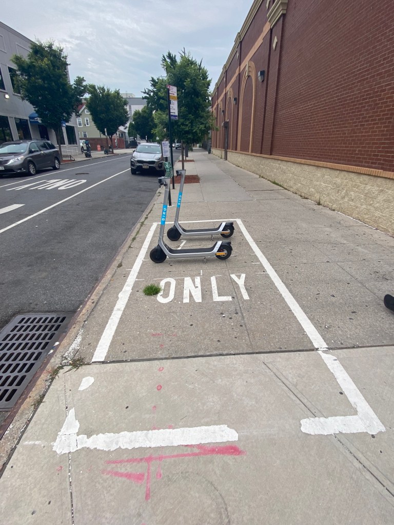
Another challenge in The Bronx that will likely be prevalent in Queens is how people park e-scooters. In The Bronx, riders were required to park in designated corrals like the one seen below if they were in certain zones designated by the NYCDOT based on high pedestrian volumes, limited sidewalk width, and community input. Otherwise, they were required to park in what was known as the “furniture zone,” or free-floating parking zone, which is the section of the sidewalk between the curb and where pedestrians walk that is typically used for installing street furniture, such as benches and bike racks. 30% of riders reported to the NYCDOT that they either found the parking regulations confusing or had difficulty finding parking spaces. Even though this information is communicated to riders during in-app training and community events hosted by companies, more may be done to ensure the knowledge and enforcement of the parking regulations. However, the NYCDOT did indicate in their report on the East Bronx pilot that compliance with parking regulations improved over time; thus, this might also become the case in Queens as well.

In addition to the issue of parking itself, 39% of riders in the Bronx found that just locating an e-scooter on the street was an issue, making it the top issue encountered amongst Bronxites, according to the NYCDOT. As there is no centralized location for parking e-scooters in most Bronx areas, the agency will likely need to work to ensure that the e-scooters are visible for Queens residents as options whenever they are needed, especially in residential areas in which there will likely be fewer designated parking corrals.
A unique challenge for Eastern Queens that was not as prevalent in The Bronx is how space will be allocated for e-scooters at the Flushing-Main St(7), Jamaica-Parsons Archer(E, J, Z) as well as the Flushing(LIRR) and Jamaica(LIRR/Airtrain JFK) stations. Space here will likely become an issue, given that the areas surrounding these transit hubs are substantially busier than that of any East Bronx station. Particularly, the sidewalks of Downtown Flushing are already among the most crowded in New York City, which will make it even harder for e-scooters to find parking spaces. As little to no space has been allocated explicitly for e-scooters near some Bronx subway stations, this will likely be a new challenge presented to the NYCDOT.
Another issue that may need to be addressed, particularly in the Downtowns but also in the other busier areas, is how e-scooters will be accommodated on already busy streets. In The Bronx, DOT observers repeatedly noticed sidewalk riding throughout the service area. While sidewalk-riding can be dangerous in all areas, it may be especially dangerous on the sometimes sardine-packed sidewalks of Downtown Flushing and Jamaica.
As for infrastructure, Eastern Queens riders south of Kissena Park and north of Downtown Jamaica between the Van Wyck Expressway on the west and 164th St on the west can enjoy a network of bike lanes, shared bike lanes, and bike routes that will provide them safer thoroughfares to get around their communities. In addition, riders can utilize bike lanes on 73rd Ave to get across Eastern Queens from Main St near 141st St, and as far out as Alley Pond Park near 230th St. For reference, street numbers in Queens increase the further east someone travels, and avenue numbers increase the further south one travels and vice versa. However, in most areas in the southern section of the zone below Downtown Jamaica, cycling infrastructure is relatively scarce, which may make fewer riders feel safe riding here than in other areas.
Disparities existed in the e-scooter zones for The Bronx, as the northern section of the zone in which Phase 1 of The Bronx pilot was implemented has significantly more cycling infrastructure than the southern section where Phase 2 of The Bronx pilot was implemented. Nonetheless, there were still higher trip origins and destination rates in the southern section, despite a lower population and an almost equivalent car ownership rate to the Phase 1 zone. This is possible due to there being more commercial areas in Phase 2 and bike lanes on Castle Hill and Morris Park Avenues, two major commercial corridors in the area. There were also more subway stations that saw more trips originate/end in the area as well. Thus, infrastructure disparities may not necessarily be the primary driver of ridership in Queens.

It is also important to note that in The Bronx, e-scooters are not allowed on greenways/bike trails, nor are they permitted on the interior trails of private apartment complexes such as Parkchester and Co-Op City despite being allowed in similarly densely populated NYCHA complexes. Thus, it is likely that e-scooters will not be allowed inside Rochdale Village in Southern Queens, the small townhouse development of Georgetown Mews in Kew Gardens Hills, or the many greenways in major parks that surround Eastern Queens. As NYCHA complexes were among the top trip origins/destination in The Bronx besides subway stations, the NYCDOT and the owners of the similarly densely populated Rochdale Village and Georgetown Mews developments, respectively, may want to collaborate to seek safe ways to allow the e-scooters on the respective residential properties. However, e-scooters will likely be allowed and thus heavily utilized in the expansive greenways of the Pomonok and Bland Houses in the Pomonok and Downtown Flushing neighborhoods, respectively. It is unclear if e-scooters will be allowed on the sprawling campus of Queens College as there is no CUNY-wide policy regarding e-scooters, nor are there any large college campuses with greenways in the East Bronx.
: The introduction of e-scooters is not the only significant micromobility improvement coming to Eastern Queens. The NYCDOT is currently working on implementing a network of standard, protected, and shared bike lanes in Queens Community District 11 in Northeastern Queens, which will serve parts of the Auburndale, Bay Terrace, Bayside, and Oakland Gardens neighborhoods. While not included in the initial e-scooter program expansion, the amount of cycling infrastructure being installed should make the area better for riding should the program be expanded here. The infrastructure here would be especially critical to the success of the e-scooter program because many of the residential streets in Northeastern Queens are extremely wide. Thus, drivers would likely have less awareness of scooters, given that such wide streets are widely known to enable speed, especially when there is limited surrounding activity density.
However, due to the neighborhoods here having a more suburban feel than other areas, finding a scooter here may be a challenge even more so than it was in The Bronx should the program be expanded. In areas like this, the city may want to require e-scooters to be parked in corrals in more places to ensure centralized locations where residents can count on being able to pick up a scooter. They might also want to consider corrals near potential key destinations such as the Bay Terrace Shopping Center, the Bayside LIRR station/Bell Blvd Commercial Strip, and Queensborough Community College.
The proposal calls for protected, standard, and shared bike lanes on several north-south and east-west corridors. A shared bike lane or sharrow is when bike symbols are placed on the ground, and signs are posted urging drivers to share the road with cyclists. As minor of a change as it may sound, they have led to a risk reduction of 18% in all NYCDOT projects studied in the NYCDOT study, “Safe Streets For Cycling: How Street Design Affects Bicycle Safety and Ridership.” In addition, the NYCDOT is proposing a miles-long “calm” corridor design for 33rd Ave from 215th Pl to Utopia Pkwy that will add traffic calming measures such as added pedestrian space and a lower speed limit and sharrows to improve safety for both cyclists and pedestrians. The “calm” corridor design is particularly important on 33rd Ave because, like many streets in CD11, it is wide and has low traffic volumes. While they will not be included as part of the bike lane network as of now, the NYCDOT is studying Utopia Pkwy for the addition of protected bike lanes as per the request of Queens Community Board(CB) 11.

The network will provide connections to key destinations such as the Bay Terrace Shopping Center, Bayside LIRR station/Bell Blvd Commerical Strip, and more. In addition, the NYCDOT is proposing a clam corridor design for 33rd Ave that will add traffic calming measures as well as Additionally, students may also be more inclined to ride their bicycles to classes at Bayside and Benjamin N Cardozo High School as an NYC Department of Health and Mental Hygiene in 2009 found that 22% of Queens students walked or biked to school most of the time. Cyclists would also have connections to some of Queens’ most popular cycling trails, such as those in Cunningham and Alley Pond Park, the Joe Michaels’ Mile, and the pedestrian/cyclist-only Vanderbilt Motor Parkway.

Benjamin N. Cardozo High School.

Even if many people do not consider riding bicycles now to get to destinations, cycling infrastructure such as standard and protected lanes tend to increase cycling propensity substantially. According to the NYCDOT study, “Safe Streets For Cycling: How Street Design Affects Bicycle Safety and Ridership,” both protected and standard bike lanes increase cycling volumes by 50%, and on the highest-risk streets, cycling volumes almost doubled following the installation of a bike lane. Given these numbers, there may be particularly high cycling increases in Northeastern Queens as its verdant and pristine landscape and limited vehicular volumes in many areas can make it a splendid cycling environment should riders feel safe riding a bike.
Despite what the network could mean for cyclists and micromobility, it has faced some community opposition. Initially, the community board opposed certain routes proposed in an earlier proposal from the NYCDOT that would have enabled a broader and more connected network. Mostly, this was due to the potential loss of parking in residential neighborhoods. This issue is prevalent as, according to car ownership data from the NYC Department of City Planning, 89% of households in CD11 own at least one vehicle and the car ownership rate is 1.44 vehicles per occupied housing unit. Thus, many residents need street parking despite most having driveways. This tally also includes residents who live in the over residents who live in apartment buildings. While the minority, these single developments where they are located can have a particularly outsized impact on parking capacity in their immediate vicinity. The over 1,000-unit Bay Club condominium complex adjacent to where the 26th Ave protected bike lanes will have no significant impact on on-street parking, however, as its residents have access to two-story parking garages with a combined 1,200 underneath their respective buildings in addition to three outdoor parking lots with 125 spots each according to the Bay Club website.
While the NYCDOT attempted to incorporate this feedback, many community members, including those opposed to lanes in certain locations, still supported a well-connected bicycle network. To do this, the NYCDOT did have to implement some, but not all, of the opposed routes in its new proposal, which has been supported by the Eastern Queens Activist Committee of the advocacy group Transportation Alternatives. After all, the board unanimously supported adding protected bike lanes after a 2021 proposal by the NYCDOT included no protected bike lanes. While this new proposal did not have the community board vote at a hearing in September 2022, there was enough support for the NYCDOT to move forward with the project. The lanes and the 33rd Ave calm corridor are expected to be constructed between now and this summer. The chairman of the CB11 Transportation Committee chair Victor Dadras told Streetsblog last September, “There are those who think it goes too far; there are those who think it doesn’t go far enough.”
These types of disagreements tend to occur on similar projects in which street space is designated for other modes, such as the community opposition to bike lanes on one of the most dangerous streets for traffic incidents in the city, which is Hylan Blvd on the similarly residential, car-dominated South Shore of Staten Island. As active modes of transportation become more popular citywide, including in less dense residential areas, a critical issue facing the city is how the city can provide the infrastructure that supports the coexistence of both modes and allows people the most freedom and flexibility regarding how they get around. As this issue is ongoing, e-scooter programs and bike lane networks may be part of the solution.
Works Cited
New York City Economic Development Corporation. New Yorkers and Their Cars | NYCEDC, 5 April 2018, https://edc.nyc/article/new-yorkers-and-their-cars. Accessed 17 June 2023.
“INRIX: Shared Bikes and Scooters Could Replace Nearly 50 Percent of Downtown Vehicle Trips.” INRIX, 9 September 2019, https://inrix.com/press-releases/micromobility-study-us-2019/. Accessed 17 June 2023.
New York City Department of Transportation. “NYC DOT Announces Queens Expansion of E-Scooter Sharing Program.” NYC.gov, 15 June 2023, https://www.nyc.gov/html/dot/html/pr2023/e-scooter-sharing-program-queens-expansion.shtml. Accessed 17 June 2023.
New York City Department of Transportation. “E-Scooters: NYC DOT Announces Micromobility Pilot in East Bronx Will Move Toward Becoming as Long-Term Program, as New Report Details Success.” NYC.gov, 14 November 2022, https://www.nyc.gov/html/dot/html/pr2022/micromobility-pilot.shtml. Accessed 17 June 2023.
New York City Department of Transportation. “East Bronx Shared E-Scooter Pilot Report 2022.” NYC.gov, November 2022, https://www.nyc.gov/html/dot/downloads/pdf/east-bronx-shared-e-scooter-pilot-report.pdf. Accessed 17 June 2023.
“Median Incomes.” Citizens’ Committee for Children, 2021, https://data.cccnewyork.org/data/map/66/median-incomes#66/39/3/107/127/a/a. Accessed 17 June 2023.
The City of New York. “NYC Bike Map 2023.” NYC.gov, 2023, https://www.nyc.gov/html/dot/downloads/pdf/nyc-bike-map-2023.pdf. Accessed 17 June 2023.
Kessler, Eve, and Kevin Duggan. “Panel Votes Down Eastern Queens Bike Lanes — But DOT Says it Will Move Forward – Streetsblog New York City.” Streetsblog NYC, 15 September 2022, https://nyc.streetsblog.org/2022/09/15/panel-votes-down-eastern-queens-bike-lanes-but-dot-says-it-will-move-forward. Accessed 17 June 2023.
New York City Department of Transportation. “CB11 AREA, QUEENS BICYCLE LANE NETWORK DEVELOPMENT REVISED PROPOSAL.” NYC.gov, 12 September 2022, https://www.nyc.gov/html/dot/downloads/pdf/qn-cb11-bike-network-sept2022.pdf. Accessed 17 June 2023.
New York City Department of Transportation. “Safe Streets For Cycling.” NYC.gov, October 2021, https://www.nyc.gov/html/dot/downloads/pdf/safe-streets-for-cycling.pdf. Accessed 17 June 2023.
New York City Department of City Planning-Transportation. “Car Ownership in NYC.” Tableau, 24 November 2022, https://public.tableau.com/app/profile/dcptransportation/viz/ACSProfiles/Dashboard1. Accessed 17 June 2023.
“The Bay Club. A residential community in Bayside, New York.” The Bay Club. A residential community in Bayside, New York, 2023, http://www.bayclub.net/info.php?pnum=2. Accessed 17 June 2023.
Bascome, Erik. “NYC to start work on community-opposed Hylan Blvd. bike lane project.” SILive.com, 28 August 2022, https://www.silive.com/news/2022/08/nyc-to-start-work-on-community-opposed-hylan-blvd-bike-lane-project.html. Accessed 17 June 2023.
